Gièvres
Gièvres ist eine Gemeinde mit 2376 Einwohnern (Stand: 1. Januar 2019) im französischen Département Loir-et-Cher der Region Centre-Val de Loire. Die Gemeinde gehört zum Arrondissement Romorantin-Lanthenay und zum Kanton Selles-sur-Cher. Die Einwohner werden Gièvrois(es) genannt.
| Gièvres | ||
|---|---|---|
.svg.png.webp)
|
| |
| Staat | Frankreich | |
| Region | Centre-Val de Loire | |
| Département (Nr.) | Loir-et-Cher (41) | |
| Arrondissement | Romorantin-Lanthenay | |
| Kanton | Selles-sur-Cher | |
| Gemeindeverband | Romorantinais et du Monestois | |
| Koordinaten | 47° 17′ N, 1° 40′ O | |
| Höhe | 72–102 m | |
| Fläche | 38,18 km² | |
| Einwohner | 2.376 (1. Januar 2019) | |
| Bevölkerungsdichte | 62 Einw./km² | |
| Postleitzahl | 41130 | |
| INSEE-Code | 41097 | |
| Website | https://www.gievres.fr/ | |
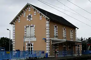 Bahnhofsgebäude | ||

Geographie
Gièvres liegt etwa zehn Kilometer südwestlich von Romorantin-Lanthenay am Canal de Berry zwischen Cher und Sauldre. Umgeben wird Gièvres von den Nachbargemeinden Pruniers-en-Sologne im Norden, Villefranche-sur-Cher im Osten, La Chapelle-Montmartin im Südosten, Chabris im Süden sowie Selles-sur-Cher im Westen.
Bevölkerungsentwicklung
| 1962 | 1968 | 1975 | 1982 | 1990 | 1999 | 2006 | 2018 |
|---|---|---|---|---|---|---|---|
| 1292 | 1254 | 1534 | 1666 | 1767 | 1999 | 2185 | 2386 |
Sehenswürdigkeiten
- Schmalspurbahn Chemin de fer du Blanc-Argent
This article is issued from Wikipedia. The text is licensed under Creative Commons - Attribution - Sharealike. The authors of the article are listed here. Additional terms may apply for the media files, click on images to show image meta data.