Villeneuve-sous-Dammartin
Villeneuve-sous-Dammartin ist eine französische Gemeinde im Département Seine-et-Marne in der Île-de-France. Sie gehört zum Kanton Mitry-Mory (bis 2015 Kanton Dammartin-en-Goële) im Arrondissement Meaux. Sie grenzt im Nordwesten an Moussy-le-Vieux, im Nordosten an Longperrier und Dammartin-en-Goële, im Südosten an Thieux und im Südwesten an Le Mesnil-Amelot. Die Bewohner nennen sich Villeneuvois.
| Villeneuve-sous-Dammartin | ||
|---|---|---|
.svg.png.webp)
|
| |
| Staat | Frankreich | |
| Region | Île-de-France | |
| Département (Nr.) | Seine-et-Marne (77) | |
| Arrondissement | Meaux | |
| Kanton | Mitry-Mory | |
| Gemeindeverband | Roissy Pays de France | |
| Koordinaten | 49° 2′ N, 2° 38′ O | |
| Höhe | 72–116 m | |
| Fläche | 7,57 km² | |
| Einwohner | 645 (1. Januar 2019) | |
| Bevölkerungsdichte | 85 Einw./km² | |
| Postleitzahl | 77230 | |
| INSEE-Code | 77511 | |

Bevölkerungsentwicklung
| Jahr | 1962 | 1968 | 1975 | 1982 | 1990 | 1999 | 2008 | 2013 |
|---|---|---|---|---|---|---|---|---|
| Einwohner | 310 | 299 | 298 | 277 | 413 | 534 | 614 | 646 |
Sehenswürdigkeiten
- Kirche Saint-Pierre-Saint-Paul (siehe auch: Liste der Monuments historiques in Villeneuve-sous-Dammartin)
- Taubenhaus
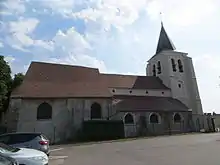
Kirche Saint-Pierre-Saint-Paul
Literatur
- Le Patrimoine des Communes de la Seine-et-Marne. Flohic Editions, Band 1, Paris 2001, ISBN 2-84234-100-7, S. 436–438.
This article is issued from Wikipedia. The text is licensed under Creative Commons - Attribution - Sharealike. The authors of the article are listed here. Additional terms may apply for the media files, click on images to show image meta data.