Dhuisy
Dhuisy ist eine französische Gemeinde mit 311 Einwohnern (Stand: 1. Januar 2019) im Département Seine-et-Marne in der Region Île-de-France. Sie gehört zum Arrondissement Meaux und zum Kanton La Ferté-sous-Jouarre (bis 2015: Kanton Lizy-sur-Ourcq). Die Einwohner werden Dhuiséens genannt.
| Dhuisy | ||
|---|---|---|
.svg.png.webp)
|
| |
| Staat | Frankreich | |
| Region | Île-de-France | |
| Département (Nr.) | Seine-et-Marne (77) | |
| Arrondissement | Meaux | |
| Kanton | La Ferté-sous-Jouarre | |
| Gemeindeverband | Pays de l’Ourcq | |
| Koordinaten | 49° 2′ N, 3° 10′ O | |
| Höhe | 117–211 m | |
| Fläche | 8,17 km² | |
| Einwohner | 311 (1. Januar 2019) | |
| Bevölkerungsdichte | 38 Einw./km² | |
| Postleitzahl | 77440 | |
| INSEE-Code | 77157 | |
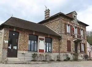 Rathaus (Mairie) von Dhuisy | ||

Geographie
Dhuisy liegt etwa 21 Kilometer ostnordöstlich von Meaux. Umgeben wird Dhuisy von den Nachbargemeinden Germigny-sous-Coulombs im Norden, Gandelu und Marigny-en-Orxois im Nordosten, Montreuil-aux-Lions im Osten, Sainte-Aulde im Süden, Chamigny im Süden und Südwesten, Cocherel im Südwesten, Vendrest im Westen sowie Coulombs-en-Valois im Nordwesten.
Bevölkerungsentwicklung
| Jahr | 1962 | 1968 | 1975 | 1982 | 1990 | 1999 | 2006 | 2013 |
| Einwohner | 163 | 157 | 136 | 184 | 220 | 241 | 261 | 293 |
| Quelle: Cassini und INSEE | ||||||||
Sehenswürdigkeiten
- Kirche Saint-Nicolas (siehe auch: Liste der Monuments historiques in Dhuisy)
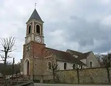
Kirche Saint-Nicolas
Literatur
- Le Patrimoine des Communes de la Seine-et-Marne. Flohic Editions, Band 1, Paris 2001, ISBN 2-84234-100-7, S. 633–634.
Weblinks
Commons: Dhuisy – Sammlung von Bildern, Videos und Audiodateien
- Dhuisy bei annuaire-mairie.fr (französisch)
This article is issued from Wikipedia. The text is licensed under Creative Commons - Attribution - Sharealike. The authors of the article are listed here. Additional terms may apply for the media files, click on images to show image meta data.