Vattetot-sous-Beaumont
Vattetot-sous-Beaumont ist eine französische Gemeinde mit 576 Einwohnern (Stand: 1. Januar 2019) im Département Seine-Maritime in der Region Normandie. Sie gehört zum Arrondissement Le Havre und zum Kanton Saint-Romain-de-Colbosc (bis 2015: Kanton Goderville).
| Vattetot-sous-Beaumont | ||
|---|---|---|
|
| |
| Staat | Frankreich | |
| Region | Normandie | |
| Département (Nr.) | Seine-Maritime (76) | |
| Arrondissement | Le Havre | |
| Kanton | Saint-Romain-de-Colbosc | |
| Gemeindeverband | Campagne-de-Caux | |
| Koordinaten | 49° 38′ N, 0° 27′ O | |
| Höhe | 93–147 m | |
| Fläche | 6,99 km² | |
| Einwohner | 576 (1. Januar 2019) | |
| Bevölkerungsdichte | 82 Einw./km² | |
| Postleitzahl | 76110 | |
| INSEE-Code | 76725 | |
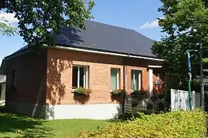 Rathaus (Mairie) von Vattetot-sous-Beaumont | ||

Geographie
Vattetot-sous-Beaumont liegt etwa 23 Kilometer nordöstlich von Le Havre in der Landschaft Pays de Caux. Umgeben wird Vattetot-sous-Beaumont von den Nachbargemeinden Gonfreville-Caillot im Norden, Saint-Maclou-la-Brière im Nordosten, Bernières im Osten, Nointot im Süden, Mirville im Südwesten sowie Bréauté im Westen.
Bevölkerungsentwicklung
| Jahr | 1962 | 1968 | 1975 | 1982 | 1990 | 1999 | 2006 | 2013 |
| Einwohner | 327 | 345 | 279 | 361 | 484 | 490 | 533 | 582 |
| Quelle: Cassini und INSEE | ||||||||
Sehenswürdigkeiten
- Kirche Notre-Dame aus dem 13. Jahrhundert
- Herrenhaus Bailleul aus dem 13./14. Jahrhundert
- Herrenhaus Brilly

Kirche Notre-Dame
This article is issued from Wikipedia. The text is licensed under Creative Commons - Attribution - Sharealike. The authors of the article are listed here. Additional terms may apply for the media files, click on images to show image meta data.