Gonneville-la-Mallet
| Gonneville-la-Mallet | ||
|---|---|---|
.svg.png.webp)
|
| |
| Staat | Frankreich | |
| Region | Normandie | |
| Département (Nr.) | Seine-Maritime (76) | |
| Arrondissement | Le Havre | |
| Kanton | Octeville-sur-Mer | |
| Gemeindeverband | Le Havre Seine Métropole | |
| Koordinaten | 49° 38′ N, 0° 13′ O | |
| Höhe | 65–137 m | |
| Fläche | 7,32 km² | |
| Einwohner | 1.371 (1. Januar 2019) | |
| Bevölkerungsdichte | 187 Einw./km² | |
| Postleitzahl | 76280 | |
| INSEE-Code | 76307 | |
| Website | https://gonneville-la-mallet.com/ | |

Gonneville-la-Mallet ist eine französische Gemeinde mit 1.371 Einwohnern (Stand: 1. Januar 2019) im Département Seine-Maritime in der Region Normandie. Sie ist dem Kanton Octeville-sur-Mer (bis 2015: Kanton Criquetot-l’Esneval) und dem Arrondissement Le Havre zugeteilt.
Geographie
Gonneville-la-Mallet liegt etwa 18 Kilometer nordnordöstlich von Le Havre nahe dem Ärmelkanal. Umgeben wird Gonneville-la-Mallet von den Nachbargemeinden Beaurepaire im Norden, Villainville im Nordosten, Anglesqueville-l’Esneval im Osten, Turretot im Südosten, Saint-Martin-du-Bec im Süden sowie Saint-Jouin-Bruneval im Westen.
Bevölkerungsentwicklung
| Jahr | 1962 | 1968 | 1975 | 1982 | 1990 | 1999 | 2006 | 2013 |
|---|---|---|---|---|---|---|---|---|
| Einwohner | 858 | 809 | 868 | 1.037 | 1.166 | 1.139 | 1.233 | 1.325 |
| Quelle: Cassini und INSEE | ||||||||
Sehenswürdigkeiten
- Kirche Saint-Pierre aus dem 19. Jahrhundert
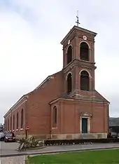
Kirche Saint-Pierre
Persönlichkeiten
- Séraphin-Médéric Mieusement (1840–1905), Fotograf
This article is issued from Wikipedia. The text is licensed under Creative Commons - Attribution - Sharealike. The authors of the article are listed here. Additional terms may apply for the media files, click on images to show image meta data.