Kanton Saint-Romain-de-Colbosc
Der Kanton Saint-Romain-de-Colbosc ist ein französischer Wahlkreis im Arrondissement Le Havre im Département Seine-Maritime in der Region Normandie; sein Hauptort ist Saint-Romain-de-Colbosc. Vertreter im Generalrat des Départements ist seit 1982 Denis Merville (UMP).
| Kanton Saint-Romain-de-Colbosc | |
|---|---|
| Region | Normandie |
| Département | Seine-Maritime |
| Arrondissement | Le Havre |
| Hauptort | Saint-Romain-de-Colbosc |
| Einwohner | 33.885 (1. Jan. 2019) |
| Bevölkerungsdichte | 105 Einw./km² |
| Fläche | 322,87 km² |
| Gemeinden | 38 |
| INSEE-Code | 7632 |
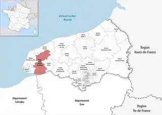 Lage des Kantons Saint-Romain-de-Colbosc im Département Seine-Maritime | |
Der Kanton Saint-Romain-de-Colbosc ist 315,43 km² groß und hat (2019) 33.885 Einwohner, was einer Bevölkerungsdichte von 107 Einwohnern pro km² entspricht.
Partnerschaften
Der Kanton Saint-Romain-de-Colbosc ist mit der niedersächsischen Gemeinde Adendorf verpartnert.[1]
Gemeinden
Der Kanton besteht aus 38 Gemeinden mit insgesamt 33.885 Einwohnern (Stand: 1. Januar 2019) auf einer Gesamtfläche von 322,87 km²:
| Gemeinde | Einwohner 1. Januar 2019 |
Fläche km² |
Dichte Einw./km² |
Code INSEE |
Postleitzahl |
|---|---|---|---|---|---|
| Angerville-Bailleul | 185 | 4,59 | 40 | 76012 | 76110 |
| Annouville-Vilmesnil | 467 | 5,84 | 80 | 76021 | 76110 |
| Auberville-la-Renault | 458 | 4,99 | 92 | 76033 | 76110 |
| Bec-de-Mortagne | 643 | 12,05 | 53 | 76068 | 76110 |
| Bénarville | 267 | 4,39 | 61 | 76076 | 76110 |
| Bornambusc | 251 | 4,18 | 60 | 76118 | 76110 |
| Bréauté | 1.359 | 13,93 | 98 | 76141 | 76110 |
| Bretteville-du-Grand-Caux | 1.360 | 11,41 | 119 | 76143 | 76110 |
| Daubeuf-Serville | 401 | 7,83 | 51 | 76213 | 76110 |
| Écrainville | 977 | 12,98 | 75 | 76224 | 76110 |
| Épretot | 776 | 6,94 | 112 | 76239 | 76430 |
| Étainhus | 1.205 | 8,33 | 145 | 76250 | 76430 |
| Goderville | 2.864 | 8,02 | 357 | 76302 | 76110 |
| Gommerville | 729 | 7,47 | 98 | 76303 | 76430 |
| Gonfreville-Caillot | 369 | 4,22 | 87 | 76304 | 76110 |
| Graimbouville | 615 | 6,43 | 96 | 76314 | 76430 |
| Grainville-Ymauville | 433 | 6,34 | 68 | 76317 | 76110 |
| Houquetot | 338 | 4,11 | 82 | 76368 | 76110 |
| La Cerlangue | 1.276 | 29,41 | 43 | 76169 | 76430 |
| La Remuée | 1.277 | 7,09 | 180 | 76522 | 76430 |
| Les Trois-Pierres | 769 | 7,52 | 102 | 76714 | 76430 |
| Manneville-la-Goupil | 1.035 | 8,85 | 117 | 76408 | 76110 |
| Mentheville | 293 | 3,10 | 95 | 76425 | 76110 |
| Oudalle | 417 | 10,73 | 39 | 76489 | 76430 |
| Sainneville | 850 | 7,05 | 121 | 76551 | 76430 |
| Saint-Aubin-Routot | 1.917 | 6,83 | 281 | 76563 | 76430 |
| Saint-Gilles-de-la-Neuville | 652 | 7,15 | 91 | 76586 | 76430 |
| Saint-Laurent-de-Brèvedent | 1.491 | 7,86 | 190 | 76596 | 76700 |
| Saint-Maclou-la-Brière | 462 | 4,93 | 94 | 76603 | 76110 |
| Saint-Romain-de-Colbosc | 4.259 | 11,77 | 362 | 76647 | 76430 |
| Saint-Sauveur-d’Émalleville | 1.229 | 7,54 | 163 | 76650 | 76110 |
| Saint-Vigor-d’Ymonville | 1.137 | 32,07 | 35 | 76657 | 76430 |
| Saint-Vincent-Cramesnil | 691 | 4,83 | 143 | 76658 | 76430 |
| Sandouville | 797 | 15,35 | 52 | 76660 | 76430 |
| Sausseuzemare-en-Caux | 430 | 3,74 | 115 | 76669 | 76110 |
| Tocqueville-les-Murs | 279 | 3,52 | 79 | 76695 | 76110 |
| Vattetot-sous-Beaumont | 576 | 6,99 | 82 | 76725 | 76110 |
| Virville | 351 | 2,49 | 141 | 76747 | 76110 |
| Kanton Saint-Romain-de-Colbosc | 33.885 | 322,87 | 105 | 7632 | – |
Bis zur Neuordnung bestand der Kanton Saint-Romain-de-Colbosc aus den 18 Gemeinden La Cerlangue, Épretot, Étainhus, Gommerville, Graimbouville, Oudalle, La Remuée, Rogerville, Sainneville, Saint-Aubin-Routot, Saint-Gilles-de-la-Neuville, Saint-Laurent-de-Brèvedent, Saint-Romain-de-Colbosc, Saint-Vigor-d’Ymonville, Saint-Vincent-Cramesnil, Sandouville, Tancarville und Les Trois-Pierres. Sein Zuschnitt entsprach einer Fläche von 187,08 km2.
Bevölkerungsentwicklung
| 1962 | 1968 | 1975 | 1982 | 1990 | 1999 | 2006 | 2011 |
|---|---|---|---|---|---|---|---|
| 10.638 | 11.774 | 13.702 | 15.422 | 17.318 | 18.705 | 19.400 | 20.333 |
Einzelnachweise
- Eintrag über die Partnerschaft zum Kanton Saint-Romain-de-Colbosc Abgerufen am 27. April 2019, 13:35