Subles
Subles ist eine Gemeinde mit 666 Einwohnern (Stand: 1. Januar 2019) in der Normandie in Frankreich. Sie gehört zum Département Calvados, zum Arrondissement Bayeux und zum Kanton Bayeux. Die Einwohner werden Sublais genannt.
| Subles | ||
|---|---|---|
| ||
| Staat | Frankreich | |
| Region | Normandie | |
| Département (Nr.) | Calvados (14) | |
| Arrondissement | Bayeux | |
| Kanton | Bayeux | |
| Gemeindeverband | Bayeux Intercom | |
| Koordinaten | 49° 15′ N, 0° 45′ W | |
| Höhe | 30–82 m | |
| Fläche | 2,44 km² | |
| Einwohner | 666 (1. Januar 2019) | |
| Bevölkerungsdichte | 273 Einw./km² | |
| Postleitzahl | 14400 | |
| INSEE-Code | 14679 | |

Geographie
Subles liegt etwa sechs Kilometer südwestlich von Bayeux am Drôme. Umgeben wird Subles von den Nachbargemeinden Ranchy im Norden und Nordwesten, Saint-Loup-Hors im Norden und Nordosten, Guéron im Nordosten, Arganchy im Osten, Saint-Paul-du-Vernay im Süden, Noron-la-Poterie im Südwesten sowie Agy im Westen.
Bevölkerungsentwicklung
| Jahr | 1962 | 1968 | 1975 | 1982 | 1990 | 1999 | 2006 | 2013 |
|---|---|---|---|---|---|---|---|---|
| Einwohner | 230 | 220 | 315 | 349 | 574 | 571 | 551 | 668 |
| Quelle: Cassini und INSEE | ||||||||
Sehenswürdigkeiten
- Kirche Saint-Martin aus dem 16. Jahrhundert
- Herrenhaus von Pézerolles aus dem 17. Jahrhundert
- Mühle von Hard aus dem 18. Jahrhundert
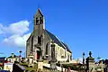 Kirche Saint-Martin
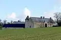 Herrenhaus von Pézerolles
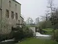 Mühle von Hard
Literatur
- Le Patrimoine des Communes du Calvados. Band 1, Flohic Editions, Paris 2001, ISBN 2-84234-111-2, S. 171–172.
This article is issued from Wikipedia. The text is licensed under Creative Commons - Attribution - Sharealike. The authors of the article are listed here. Additional terms may apply for the media files, click on images to show image meta data.