Cahagnolles
Cahagnolles ist eine französische Gemeinde im Département Calvados in der Region Normandie (vor 2016 Basse-Normandie) mit 252 Einwohnern (Stand 1. Januar 2019). Cahagnolles gehört zum Arrondissement Bayeux und zum Kanton Trévières (bis 2015 Balleroy). Die Einwohner werden Cahagnollais genannt.
| Cahagnolles | ||
|---|---|---|
| ||
| Staat | Frankreich | |
| Region | Normandie | |
| Département (Nr.) | Calvados (14) | |
| Arrondissement | Bayeux | |
| Kanton | Trévières | |
| Gemeindeverband | Isigny-Omaha Intercom | |
| Koordinaten | 49° 10′ N, 0° 46′ W | |
| Höhe | 83–139 m | |
| Fläche | 7,21 km² | |
| Einwohner | 252 (1. Januar 2019) | |
| Bevölkerungsdichte | 35 Einw./km² | |
| Postleitzahl | 14490 | |
| INSEE-Code | 14121 | |
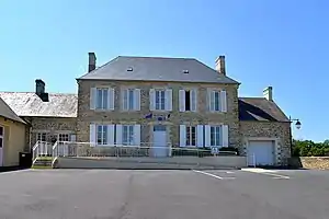 Rathaus (Mairie) von Cahagnolles | ||

Geografie
Cahagnolles liegt etwa 27 Kilometer südsüdwestlich von Bayeux. Umgeben wird Cahagnolles von den Nachbargemeinden Saint-Paul-du-Vernay im Norden, Aurseulles im Osten, Livry und Sainte-Honorine-de-Ducy im Süden, Foulognes im Südwesten sowie Planquery im Westen.
Bevölkerungsentwicklung
| 1962 | 1968 | 1975 | 1982 | 1990 | 1999 | 2006 | 2013 |
|---|---|---|---|---|---|---|---|
| 252 | 216 | 160 | 148 | 172 | 177 | 210 | 256 |
| Quelle: Cassini und INSEE | |||||||
Sehenswürdigkeiten

Kirche Saint-Pierre
- Kirche Saint-Pierre
- Schloss Vercreuil aus dem 17. Jahrhundert
Literatur
- Le Patrimoine des Communes du Calvados. Band 1, Flohic Editions, Paris 2001, ISBN 2-84234-111-2, S. 88.
This article is issued from Wikipedia. The text is licensed under Creative Commons - Attribution - Sharealike. The authors of the article are listed here. Additional terms may apply for the media files, click on images to show image meta data.