Castillon (Calvados)
Castillon ist eine französische Gemeinde im Département Calvados in der Region Normandie mit 349 Einwohnern (Stand: 1. Januar 2019). Castillon gehört zum Arrondissement Bayeux und zum Kanton Trévières. Die Einwohner werden Castillonais genannt.
| Castillon | ||
|---|---|---|
| ||
| Staat | Frankreich | |
| Region | Normandie | |
| Département (Nr.) | Calvados (14) | |
| Arrondissement | Bayeux | |
| Kanton | Trévières | |
| Gemeindeverband | Isigny-Omaha Intercom | |
| Koordinaten | 49° 12′ N, 0° 48′ W | |
| Höhe | 39–132 m | |
| Fläche | 11,09 km² | |
| Einwohner | 349 (1. Januar 2019) | |
| Bevölkerungsdichte | 31 Einw./km² | |
| Postleitzahl | 14490 | |
| INSEE-Code | 14140 | |
_mairie.JPG.webp) Rathaus (Mairie) von Castillon | ||

Geografie
Castillon liegt etwa 17 Kilometer südwestlich von Bayeux. Umgeben wird Castillon von den Nachbargemeinden Balleroy-sur-Drôme im Norden, Le Tronquay im Norden, Noron-la-Poterie im Nordosten, Saint-Paul-du-Vernay im Osten, Cahagnolles im Süden und Südosten, Planquery im Süden und Südwesten sowie Balleroy-sur-Drôme im Westen und Nordwesten.
Bevölkerungsentwicklung
| 1962 | 1968 | 1975 | 1982 | 1990 | 1999 | 2006 | 2013 |
|---|---|---|---|---|---|---|---|
| 331 | 325 | 298 | 294 | 284 | 308 | 295 | 332 |
| Quelle: Cassini und INSEE | |||||||
Sehenswürdigkeiten
- gallisches Oppidum
- Kirche Saint-Cassien aus dem 15. Jahrhundert
- Schloss von 1762, Monument historique, mit Wassermühle
- Park von Castillon-Plantbessin, 1985 angelegt
- Brücke von Sully, seit 1990 Monument historique
_Fa%C3%A7ade_occidentale_de_l'%C3%A9glise.JPG.webp) Kirche Saint-Cassien
Kirche Saint-Cassien.jpg.webp) Park von Castillon-Plantbessin
Park von Castillon-Plantbessin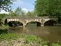 Brücke von Sully
Literatur
- Le Patrimoine des Communes du Calvados. Band 1, Flohic Editions, Paris 2001, ISBN 2-84234-111-2, S. 92–93.
This article is issued from Wikipedia. The text is licensed under Creative Commons - Attribution - Sharealike. The authors of the article are listed here. Additional terms may apply for the media files, click on images to show image meta data.