Planquery
Planquery ist eine französische Gemeinde im Département Calvados in der Region Normandie mit 246 Einwohnern (Stand: 1. Januar 2019). Planquery gehört zum Arrondissement Bayeux und zum Kanton Trévières.
| Planquery | ||
|---|---|---|
| ||
| Staat | Frankreich | |
| Region | Normandie | |
| Département (Nr.) | Calvados (14) | |
| Arrondissement | Bayeux | |
| Kanton | Trévières | |
| Gemeindeverband | Isigny-Omaha Intercom | |
| Koordinaten | 49° 9′ N, 0° 50′ W | |
| Höhe | 60–143 m | |
| Fläche | 14,54 km² | |
| Einwohner | 246 (1. Januar 2019) | |
| Bevölkerungsdichte | 17 Einw./km² | |
| Postleitzahl | 14490 | |
| INSEE-Code | 14506 | |

Geografie
Planquery liegt etwa 22 Kilometer südwestlich von Bayeux. Umgeben wird Planquery von den Nachbargemeinden Balleroy-sur-Drôme im Norden, Castillon im Norden und Nordosten, Cahagnolles im Osten, Foulognes im Osten und Südosten, Sallen im Süden, Cormolain im Süden und Südwesten sowie La Bazoque im Westen und Südwesten.
Bevölkerungsentwicklung
| 1962 | 1968 | 1975 | 1982 | 1990 | 1999 | 2006 | 2013 |
|---|---|---|---|---|---|---|---|
| 284 | 277 | 251 | 217 | 255 | 241 | 219 | 218 |
| Quelle: Cassini und INSEE | |||||||
Sehenswürdigkeiten
- Kirche Saint-André aus dem 13. Jahrhundert
- Kommanderie des Tempelritterordens von Baugy mit Kapelle (Monument historique seit 1995), 1148 gegründet
- Schloss aus dem 17. Jahrhundert
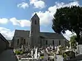 Kirche Saint-André
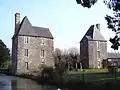 Schloss
Literatur
- Le Patrimoine des Communes du Calvados. Band 1, Flohic Editions, Paris 2001, ISBN 2-84234-111-2, S. 119–121.
This article is issued from Wikipedia. The text is licensed under Creative Commons - Attribution - Sharealike. The authors of the article are listed here. Additional terms may apply for the media files, click on images to show image meta data.