Sainte-Souline
Sainte-Souline ist eine westfranzösische Gemeinde mit 121 Einwohnern (Stand: 1. Januar 2019) im Département Charente in der Region Nouvelle-Aquitaine (vor 2016 Poitou-Charentes). Die Gemeinde gehört zum Arrondissement Cognac und zum Kanton Charente-Sud (bis 2015: Brossac).
| Sainte-Souline | ||
|---|---|---|
| ||
| Staat | Frankreich | |
| Region | Nouvelle-Aquitaine | |
| Département (Nr.) | Charente (16) | |
| Arrondissement | Cognac | |
| Kanton | Charente-Sud | |
| Gemeindeverband | 4B Sud Charente | |
| Koordinaten | 45° 23′ N, 0° 1′ W | |
| Höhe | 98–186 m | |
| Fläche | 7,34 km² | |
| Einwohner | 121 (1. Januar 2019) | |
| Bevölkerungsdichte | 16 Einw./km² | |
| Postleitzahl | 16480 | |
| INSEE-Code | 16354 | |
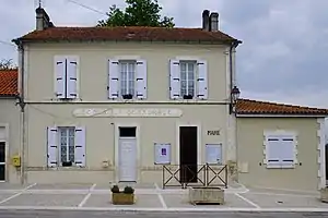 Rathaus (Mairie) von Sainte-Souline | ||

Lage
Sainte-Souline liegt etwa 31 Kilometer südsüdwestlich von Angoulême. Umgeben ist Sainte-Souline von den Nachbargemeinden Poullignac im Norden, Saint-Félix im Osten, Châtignac im Süden und Südosten, Passirac im Südwesten sowie Berneuil im Westen und Nordwesten.
Bevölkerungsentwicklung
| Jahr | 1962 | 1968 | 1975 | 1982 | 1990 | 1999 | 2006 | 2013 |
| Einwohner | 190 | 159 | 112 | 121 | 104 | 113 | 123 | 109 |
| Quelle: Cassini und INSEE | ||||||||
Sehenswürdigkeiten
- Kirche Sainte-Souline aus dem 12. Jahrhundert, Monument historique
- Pfarrhaus von 1668, Monument historique
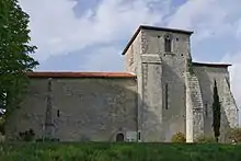
Kirche Sainte-Souline
This article is issued from Wikipedia. The text is licensed under Creative Commons - Attribution - Sharealike. The authors of the article are listed here. Additional terms may apply for the media files, click on images to show image meta data.