Sainte-Honorine-du-Fay
| Sainte-Honorine-du-Fay | ||
|---|---|---|
.svg.png.webp)
|
| |
| Staat | Frankreich | |
| Region | Normandie | |
| Département (Nr.) | Calvados (14) | |
| Arrondissement | Caen | |
| Kanton | Évrecy | |
| Gemeindeverband | Vallées de l’Orne et de l’Odon | |
| Koordinaten | 49° 5′ N, 0° 30′ W | |
| Höhe | 10–156 m | |
| Fläche | 7,61 km² | |
| Einwohner | 1.340 (1. Januar 2019) | |
| Bevölkerungsdichte | 176 Einw./km² | |
| Postleitzahl | 14210 | |
| INSEE-Code | 14592 | |
| Website | http://www.ste-honorine-du-fay.fr/ | |
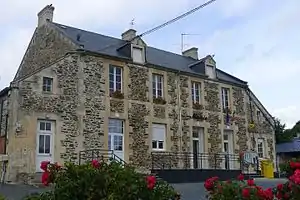 Rathaus (Mairie) von Sainte-Honorine-du-Fay | ||

Sainte-Honorine-du-Fay ist eine französische Gemeinde mit 1.340 Einwohnern (Stand: 1. Januar 2019) im Département Calvados in der Region Normandie; sie gehört zum Arrondissement Caen und zum Kanton Évrecy.
Geographie
Sainte-Honorine-du-Fay liegt etwa 15 Kilometer südöstlich von Caen. Umgeben wird Sainte-Honorine-du-Fay von den Nachbargemeinden Évrecy im Norden, Maizet im Osten und Nordosten, Grimbosq im Südosten, Montillières-sur-Orne mit Trois-Monts im Süden, Préaux-Bocage im Süden und Südwesten, Maisoncelles-sur-Ajon im Südwesten sowie Vacognes-Neuilly im Westen und Nordwesten.
Bevölkerungsentwicklung
| 1962 | 1968 | 1975 | 1982 | 1990 | 1999 | 2006 | 2013 |
|---|---|---|---|---|---|---|---|
| 427 | 495 | 644 | 927 | 1.065 | 1.085 | 1.151 | 1.323 |
| Quelle: Cassini und INSEE | |||||||
Sehenswürdigkeiten
- Kirche
- Kapelle La Jalousie
- Herrenhaus Flagy
- Waschhäuser
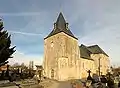 Kirche
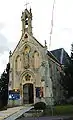 Kapelle La Jalousie
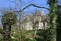 Herrenhaus Flagy
Literatur
- Le Patrimoine des Communes du Calvados. Band 1, Flohic Editions, Paris 2001, ISBN 2-84234-111-2, S. 785–786.
This article is issued from Wikipedia. The text is licensed under Creative Commons - Attribution - Sharealike. The authors of the article are listed here. Additional terms may apply for the media files, click on images to show image meta data.