Saint-Aubin-d’Arquenay
| Saint-Aubin-d’Arquenay | ||
|---|---|---|
|
| |
| Staat | Frankreich | |
| Region | Normandie | |
| Département (Nr.) | Calvados (14) | |
| Arrondissement | Caen | |
| Kanton | Ouistreham | |
| Gemeindeverband | Caen la Mer | |
| Koordinaten | 49° 16′ N, 0° 17′ W | |
| Höhe | 14–46 m | |
| Fläche | 3,30 km² | |
| Einwohner | 1.093 (1. Januar 2019) | |
| Bevölkerungsdichte | 331 Einw./km² | |
| Postleitzahl | 14970 | |
| INSEE-Code | 14558 | |
| Website | www.saintaubindarquenay.fr | |
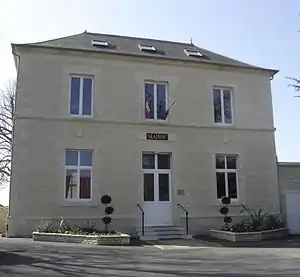 Rathaus von Saint-Aubin-d’Arquenay | ||

Saint-Aubin-d’Arquenay ist eine französische Gemeinde mit 1.093 Einwohnern (Stand: 1. Januar 2019) im Kanton Ouistreham des Départements Calvados in der Region Normandie. Périers-sur-le-Dan gehört zum Arrondissement Caen; seine Einwohner werden Saint-Aubinais genannt.
Geographie
Saint-Aubin-d’Arquenay liegt nahe der Küste zum Ärmelkanal. Umgeben wird Saint-Aubin-d’Arquenay von den Nachbargemeinden Ouistreham im Norden und Osten, Bénouville im Süden und Südosten sowie Colleville-Montgomery im Westen und Nordwesten.
Bevölkerungsentwicklung
| 1962 | 1968 | 1975 | 1982 | 1990 | 1999 | 2006 | 2012 | |
|---|---|---|---|---|---|---|---|---|
| 264 | 326 | 403 | 504 | 567 | 633 | 777 | 782 | |
| Quelle: Cassini und INSEE | ||||||||
Sehenswürdigkeiten

Kirche Saint-Aubin
- Kirche Saint-Ouenteilweise aus dem 11. Jahrhundert
- Wald von Le Caprice
- Schloss Lorzat
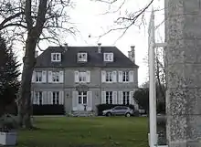
Schloss Lorzat
This article is issued from Wikipedia. The text is licensed under Creative Commons - Attribution - Sharealike. The authors of the article are listed here. Additional terms may apply for the media files, click on images to show image meta data.