Saint-Uniac
Saint-Uniac (bretonisch: Sant-Tewiniav, Gallo: Saent-Tuniau) ist eine französische Gemeinde mit 1.707 Einwohnern (Stand: 1. Januar 2019) im Département Ille-et-Vilaine in der Region Bretagne; sie gehört administrativ zum Arrondissement Rennes und ist Teil des Kantons Montauban-de-Bretagne. Die Einwohner werden Saint-Uniacais genannt.
| Saint-Uniac Sant-Tewiniav | ||
|---|---|---|
| ||
| Staat | Frankreich | |
| Region | Bretagne | |
| Département (Nr.) | Ille-et-Vilaine (35) | |
| Arrondissement | Rennes | |
| Kanton | Montauban-de-Bretagne | |
| Gemeindeverband | Saint-Méen Montauban | |
| Koordinaten | 48° 10′ N, 2° 2′ W | |
| Höhe | 45–96 m | |
| Fläche | 6,88 km² | |
| Einwohner | 540 (1. Januar 2019) | |
| Bevölkerungsdichte | 78 Einw./km² | |
| Postleitzahl | 35360 | |
| INSEE-Code | 35320 | |

Geographie
Saint-Uniac liegt etwa 26 Kilometer westnordwestlich von Rennes. Umgeben wird Saint-Uniac von den Nachbargemeinden Montauban-de-Bretagne im Norden, Iffendic im Süden und Osten sowie Boisgervilly im Westen.
Bevölkerungsentwicklung
| Jahr | 1962 | 1968 | 1975 | 1982 | 1990 | 1999 | 2006 | 2013 |
| Einwohner | 260 | 236 | 233 | 274 | 344 | 350 | 428 | 514 |
| Quelle: Cassini und INSEE | ||||||||
Sehenswürdigkeiten
Siehe auch: Liste der Monuments historiques in Saint-Uniac
- Kirche Saint-Uniac
- Herrenhaus Quénétain mit Taubenturm
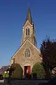 Kirche Saint-Uniac
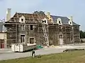 Herrenhaus Quénétain
Literatur
- Le Patrimoine des Communes d’Ille-et-Vilaine. Flohic Editions, Band 2, Paris 2000, ISBN 2-84234-072-8, S. 968–969.
Weblinks
Commons: Saint-Uniac – Sammlung von Bildern, Videos und Audiodateien
This article is issued from Wikipedia. The text is licensed under Creative Commons - Attribution - Sharealike. The authors of the article are listed here. Additional terms may apply for the media files, click on images to show image meta data.