Saint-Malon-sur-Mel
Saint-Malon-sur-Mel (bretonisch: Sant-Malon; Gallo: Saent-Méha) ist eine französische Gemeinde mit 578 Einwohnern (Stand: 1. Januar 2019) im Département Ille-et-Vilaine in der Region Bretagne; sie gehört zum Arrondissement Rennes und zum Kanton Montauban-de-Bretagne (bis 2015: Kanton Saint-Méen-le-Grand). Die Einwohner werden Malonnais genannt.
| Saint-Malon-sur-Mel Sant-Malon | ||
|---|---|---|

|
| |
| Staat | Frankreich | |
| Region | Bretagne | |
| Département (Nr.) | Ille-et-Vilaine (35) | |
| Arrondissement | Rennes | |
| Kanton | Montauban-de-Bretagne | |
| Gemeindeverband | Saint-Méen Montauban | |
| Koordinaten | 48° 6′ N, 2° 6′ W | |
| Höhe | 46–116 m | |
| Fläche | 16,23 km² | |
| Einwohner | 578 (1. Januar 2019) | |
| Bevölkerungsdichte | 36 Einw./km² | |
| Postleitzahl | 35750 | |
| INSEE-Code | 35290 | |
| Website | https://saintmalonsurmel.com/ | |
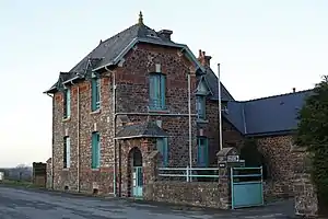 Rathaus (Mairie) von Saint-Malon-sur-Mel | ||

Geographie
Saint-Malon-sur-Mel liegt etwa 30 Kilometer westlich von Rennes. Umgeben wird Saint-Malon-sur-Mel von den Nachbargemeinden Bléruais im Norden, Saint-Gonlay im Norden und Nordosten, Iffendic im Osten, Paimpont im Süden und Südwesten sowie Muel im Westen und Nordwesten.
Bevölkerungsentwicklung
| Jahr | 1962 | 1968 | 1975 | 1982 | 1990 | 1999 | 2006 | 2013 |
| Einwohner | 644 | 554 | 492 | 449 | 447 | 447 | 527 | 608 |
| Quelle: Cassini und INSEE | ||||||||
Sehenswürdigkeiten
- Menhir La Chaise du Diable
- Kirche Saint-Malo
- Kapelle Saint-Jean aus dem Jahre 1890
- Altes Pfarrhaus
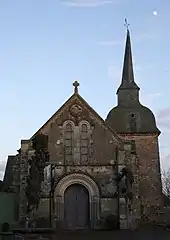
Kirche Saint-Malo
Literatur
- Le Patrimoine des Communes d’Ille-et-Vilaine. Flohic Editions, Band 2, Paris 2000, ISBN 2-84234-072-8, S. 1588–1591.
Weblinks
Commons: Saint-Malon-sur-Mel – Sammlung von Bildern, Videos und Audiodateien
This article is issued from Wikipedia. The text is licensed under Creative Commons - Attribution - Sharealike. The authors of the article are listed here. Additional terms may apply for the media files, click on images to show image meta data.