Saint-Thiébault
Saint-Thiébault ist eine französische Gemeinde im Département Haute-Marne in der Region Grand Est. Sie gehört zum Arrondissement Chaumont und zum Kanton Poissons
| Saint-Thiébault | ||
|---|---|---|
| ||
| Staat | Frankreich | |
| Region | Grand Est | |
| Département (Nr.) | Haute-Marne (52) | |
| Arrondissement | Chaumont | |
| Kanton | Poissons | |
| Gemeindeverband | Communauté de communes Meuse Rognon | |
| Koordinaten | 48° 12′ N, 5° 35′ O | |
| Höhe | 309–335 m | |
| Fläche | 0,61 km² | |
| Einwohner | 236 (1. Januar 2019) | |
| Bevölkerungsdichte | 387 Einw./km² | |
| Postleitzahl | 52150 | |
| INSEE-Code | 52455 | |
.jpg.webp) Saint-Thiébault | ||

Geografie
Die Gemeinde Saint-Thiébault liegt an der oberen Maas in der Landschaft Bassigny, 30 Kilometer westlich von Vittel. Umgeben wird Saint-Thiébault von den Nachbargemeinden Illoud im Nordwesten und Bourmont-entre-Meuse-et-Mouzon im Osten.
Bevölkerungsentwicklung
| Jahr | 1962 | 1968 | 1975 | 1982 | 1990 | 1999 | 2008 | 2019 |
|---|---|---|---|---|---|---|---|---|
| Einwohner | 212 | 316 | 400 | 331 | 295 | 279 | 293 | 236 |
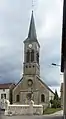 Kirche St. Theobald
 Rathaus (Mairie) und Gefallenendenkmal
Weblinks
Commons: Saint-Thiébault – Sammlung von Bildern, Videos und Audiodateien
This article is issued from Wikipedia. The text is licensed under Creative Commons - Attribution - Sharealike. The authors of the article are listed here. Additional terms may apply for the media files, click on images to show image meta data.