Millières (Haute-Marne)
Millières ist eine französische Gemeinde mit 117 Einwohnern (Stand 1. Januar 2019) im Département Haute-Marne in der Region Grand Est (vor 2016 Champagne-Ardenne). Sie gehört zum Arrondissement Chaumont und zum Kanton Poissons. Die Einwohner werden Millièrois oder Molériens genannt.
| Millières | ||
|---|---|---|
| ||
| Staat | Frankreich | |
| Region | Grand Est | |
| Département (Nr.) | Haute-Marne (52) | |
| Arrondissement | Chaumont | |
| Kanton | Poissons | |
| Gemeindeverband | Meuse Rognon | |
| Koordinaten | 48° 8′ N, 5° 28′ O | |
| Höhe | 345–457 m | |
| Fläche | 14,10 km² | |
| Einwohner | 117 (1. Januar 2019) | |
| Bevölkerungsdichte | 8 Einw./km² | |
| Postleitzahl | 52240 | |
| INSEE-Code | 52325 | |

Geographie
Millières liegt etwa 22 Kilometer ostnordöstlich von Chaumont. Umgeben wird Millières von den Nachbargemeinden Consigny im Norden, Ozières im Nordosten, Thol-lès-Millières im Osten, Longchamp im Osten und Südosten, Mennouveaux im Süden und Südwesten, Ageville im Südwesten, Esnouveaux im Westen sowie Forcey im Nordwesten.
Bevölkerungsentwicklung
| Jahr | 1962 | 1968 | 1975 | 1982 | 1990 | 1999 | 2006 | 2011 | 2018 |
|---|---|---|---|---|---|---|---|---|---|
| Einwohner | 191 | 161 | 118 | 111 | 112 | 125 | 127 | 121 | 116 |
| Quellen: Cassini und INSEE | |||||||||
Sehenswürdigkeiten
- Kirche Saint-Gengoulph
- Waschhaus
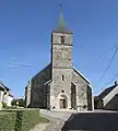 Kirche Saint-Gengoulph
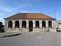 Waschhaus
Weblinks
Commons: Millières – Sammlung von Bildern, Videos und Audiodateien
This article is issued from Wikipedia. The text is licensed under Creative Commons - Attribution - Sharealike. The authors of the article are listed here. Additional terms may apply for the media files, click on images to show image meta data.