Saint-Hilaire (Allier)
Saint-Hilaire ist eine französische Gemeinde mit 529 Einwohnern (Stand 1. Januar 2019) im Département Allier in der Region Auvergne-Rhône-Alpes. Sie gehört zum Arrondissement Moulins und zum Kanton Bourbon-l'Archambault.
| Saint-Hilaire | ||
|---|---|---|
|
| |
| Staat | Frankreich | |
| Region | Auvergne-Rhône-Alpes | |
| Département (Nr.) | Allier (03) | |
| Arrondissement | Moulins | |
| Kanton | Bourbon-l'Archambault | |
| Gemeindeverband | Bocage Bourbonnais | |
| Koordinaten | 46° 30′ N, 3° 1′ O | |
| Höhe | 265–420 m | |
| Fläche | 20,94 km² | |
| Einwohner | 529 (1. Januar 2019) | |
| Bevölkerungsdichte | 25 Einw./km² | |
| Postleitzahl | 03440 | |
| INSEE-Code | 03238 | |
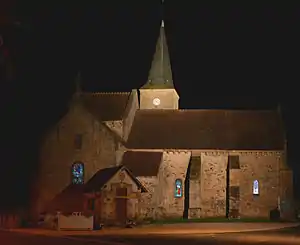 Kirche Saint Loup | ||

Geographie
Die Gemeinde liegt etwa 30 Kilometer westlich von Moulins. Nachbargemeinden sind Saint-Aubin-le-Monial im Norden, Gipcy im Osten, Rocles im Süden und Buxières-les-Mines im Westen.
Bevölkerungsentwicklung
| Jahr | 1962 | 1968 | 1975 | 1982 | 1990 | 1999 | 2006 | 2014 |
| Einwohner | 1008 | 902 | 700 | 650 | 595 | 567 | 545 | 520 |
| Quellen: Cassini und INSEE | ||||||||
Sehenswürdigkeiten
Siehe: Liste der Monuments historiques in Saint-Hilaire (Allier)
Literatur
- Le Patrimoine des Communes de l’Allier. Flohic Editions, Band 1, Paris 1999, ISBN 2-84234-053-1, S. 51–53.
This article is issued from Wikipedia. The text is licensed under Creative Commons - Attribution - Sharealike. The authors of the article are listed here. Additional terms may apply for the media files, click on images to show image meta data.