Chapeau (Allier)
| Chapeau | ||
|---|---|---|
.svg.png.webp)
|
| |
| Staat | Frankreich | |
| Region | Auvergne-Rhône-Alpes | |
| Département (Nr.) | Allier (03) | |
| Arrondissement | Moulins | |
| Kanton | Moulins-2 | |
| Gemeindeverband | Moulins Communauté | |
| Koordinaten | 46° 29′ N, 3° 31′ O | |
| Höhe | 239–285 m | |
| Fläche | 33,82 km² | |
| Einwohner | 237 (1. Januar 2019) | |
| Bevölkerungsdichte | 7 Einw./km² | |
| Postleitzahl | 03340 | |
| INSEE-Code | 03054 | |

Chapeau ist eine französische Gemeinde mit 237 Einwohnern (Stand: 1. Januar 2019) im Département Allier in der Region Auvergne-Rhône-Alpes; sie gehört zum Arrondissement Moulins und zum Kanton Moulins-2.
Geografie
Chapeau liegt etwa 14 Kilometer südöstlich von Moulins am Acolin. Umgeben wird Chapeau von den Nachbargemeinden Montbeugny im Norden, Thiel-sur-Acolin im Osten und Nordosten, Vaumas im Südosten, Mercy im Süden sowie Neuilly-le-Réal im Westen.
Bevölkerungsentwicklung
| Jahr | 1962 | 1968 | 1975 | 1982 | 1990 | 1999 | 2006 | 2013 |
| Einwohner | 294 | 329 | 295 | 300 | 264 | 216 | 219 | 228 |
| Quellen: Cassini und INSEE | ||||||||
Sehenswürdigkeiten
Siehe auch: Liste der Monuments historiques in Chapeau (Allier)
- Schloss und Domäne La Cour, Monument historique
- Schloss Les Chevennes
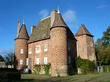
Schloss La Cour
Literatur
- Le Patrimoine des Communes de l’Allier. Flohic Editions, Band 2, Paris 1999, ISBN 2-84234-053-1, S. 915–919.
This article is issued from Wikipedia. The text is licensed under Creative Commons - Attribution - Sharealike. The authors of the article are listed here. Additional terms may apply for the media files, click on images to show image meta data.