Roure (Alpes-Maritimes)
Roure ist eine französische Gemeinde im Département Alpes-Maritimes in der Region Provence-Alpes-Côte d’Azur. Sie gehört zum Arrondissement Nizza, zum Kanton Tourrette-Levens und zur Métropole Nice Côte d’Azur. Die Bewohner nennen sich Rourois.
| Roure | ||
|---|---|---|
.svg.png.webp)
|
| |
| Staat | Frankreich | |
| Region | Provence-Alpes-Côte d’Azur | |
| Département (Nr.) | Alpes-Maritimes (06) | |
| Arrondissement | Nizza | |
| Kanton | Tourrette-Levens | |
| Gemeindeverband | Nice Côte d’Azur | |
| Koordinaten | 44° 5′ N, 7° 5′ O | |
| Höhe | 500–2339 m | |
| Fläche | 39,62 km² | |
| Einwohner | 119 (1. Januar 2019) | |
| Bevölkerungsdichte | 3 Einw./km² | |
| Postleitzahl | 06420 | |
| INSEE-Code | 06111 | |
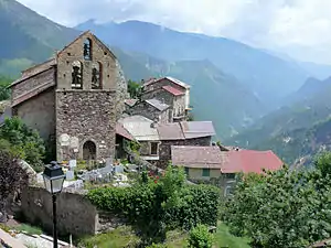 Kirche Saint-Sébastien | ||

Geographie
Roure liegt in den französischen Seealpen. Sie grenzt im Norden an Isola, im Osten an Saint-Sauveur-sur-Tinée, im Süden an Ilonse und im Westen an Roubion.
Bevölkerungsentwicklung
| Jahr | 1962 | 1968 | 1975 | 1982 | 1990 | 1999 | 2008 | 2012 |
|---|---|---|---|---|---|---|---|---|
| Einwohner | 91 | 98 | 71 | 112 | 147 | 167 | 210 | 205 |
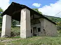
Sehenswürdigkeiten
Siehe: Liste der Monuments historiques in Roure (Alpes-Maritimes)
 Kapelle Saint-Sébastien
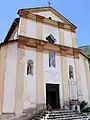 Kirche Saint-Laurent
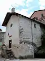
Literatur
- Le Patrimoine des Communes des Alpes-Maritimes. Flohic Editions, Band 2, Paris 2000, ISBN 2-84234-071-X, S. 863–865.
This article is issued from Wikipedia. The text is licensed under Creative Commons - Attribution - Sharealike. The authors of the article are listed here. Additional terms may apply for the media files, click on images to show image meta data.