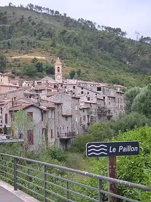
L’Escarène
L’Escarène (in italienisch Scarena) ist eine französische Gemeinde im Département Alpes-Maritimes in der Region Provence-Alpes-Côte d’Azur. Sie gehört zum Kanton Contes im Arrondissement Nizza. Die Bewohner nennen sich die Escarénois.
| L’Escarène | ||
|---|---|---|

|
| |
| Staat | Frankreich | |
| Region | Provence-Alpes-Côte d’Azur | |
| Département (Nr.) | Alpes-Maritimes (06) | |
| Arrondissement | Nizza | |
| Kanton | Contes | |
| Gemeindeverband | Pays des Paillons | |
| Koordinaten | 43° 50′ N, 7° 21′ O | |
| Höhe | 220–1054 m | |
| Fläche | 10,54 km² | |
| Einwohner | 2.554 (1. Januar 2019) | |
| Bevölkerungsdichte | 242 Einw./km² | |
| Postleitzahl | 06440 | |
| INSEE-Code | 06057 | |
 L’Escarène | ||

Geographie
L’Escarène liegt in den französischen Seealpen. Die angrenzenden Gemeinden sind:
- Lucéram und Touët-de-l’Escarène im Norden,
- Peille im Osten,
- Blausasc im Süden,
- Berre-les-Alpes im Westen.
Durch L’Escarène fließt der Paillon. Die Ortschaft wird von der normalspurigen Eisenbahnstrecke Nizza–Breil-sur-Roya (Zweigstrecke der Tendabahn) bedient.
Bevölkerungsentwicklung
| Jahr | 1962 | 1968 | 1975 | 1982 | 1990 | 1999 | 2008 | 2012 |
|---|---|---|---|---|---|---|---|---|
| Einwohner | 1.223 | 1.619 | 1.553 | 1.424 | 1.751 | 2.128 | 2.342 | 2.449 |
Sehenswürdigkeiten
Siehe: Liste der Monuments historiques in L’Escarène
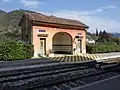 Bahnhof von L’Escarène
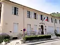 Rathaus von L’Escarène
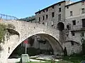 Pont-Vieux
 Kirche Saint-Pierre-ès-Liens
Literatur
- Le Patrimoine des Communes des Alpes-Maritimes. Flohic Editions, Band 1, Paris 2000, ISBN 2-84234-071-X, S. 342–346.
Weblinks
Commons: L'Escarène – Sammlung von Bildern, Videos und Audiodateien
This article is issued from Wikipedia. The text is licensed under Creative Commons - Attribution - Sharealike. The authors of the article are listed here. Additional terms may apply for the media files, click on images to show image meta data.