Plan-de-Baix
Plan-de-Baix (okzitanisch: Lo Plan de Bais) ist eine französische Gemeinde mit 147 Einwohnern (Stand: 1. Januar 2019) im Département Drôme in der Region Auvergne-Rhône-Alpes; sie gehört zum Arrondissement Die und zum Kanton Crest (bis 2015: Kanton Crest-Nord).
| Plan-de-Baix Lo Plan de Bais | ||
|---|---|---|
| ||
| Staat | Frankreich | |
| Region | Auvergne-Rhône-Alpes | |
| Département (Nr.) | Drôme (26) | |
| Arrondissement | Die | |
| Kanton | Crest | |
| Gemeindeverband | Val de Drôme | |
| Koordinaten | 44° 49′ N, 5° 10′ O | |
| Höhe | 349–1093 m | |
| Fläche | 19,55 km² | |
| Einwohner | 147 (1. Januar 2019) | |
| Bevölkerungsdichte | 8 Einw./km² | |
| Postleitzahl | 26400 | |
| INSEE-Code | 26240 | |
 Rathaus (Mairie) von Plan-de-Baix | ||

Geografie
Plan-de-Baix liegt etwa 25 Kilometer südöstlich von Valence. Umgeben wird Plan-de-Baix von den Nachbargemeinden Le Chaffal im Norden, Omblèze im Osten und Nordosten, Eygluy-Escoulin im Südosten, Beaufort-sur-Gervanne im Süden sowie Gigors-et-Lozeron im Westen und Südwesten.
Bevölkerungsentwicklung
| Jahr | 1962 | 1968 | 1975 | 1982 | 1990 | 1999 | 2006 | 2016 | |
|---|---|---|---|---|---|---|---|---|---|
| Einwohner | 123 | 142 | 125 | 139 | 123 | 134 | 143 | 145 | |
| Quellen: Cassini und INSEE | |||||||||
Sehenswürdigkeiten
- Burg Montrond
- Fels von Le Vellan
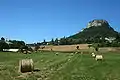 Fels von Le Vellan
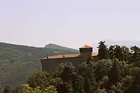 Burg Montrond
This article is issued from Wikipedia. The text is licensed under Creative Commons - Attribution - Sharealike. The authors of the article are listed here. Additional terms may apply for the media files, click on images to show image meta data.