Saou
Saou ist eine Gemeinde im französischen Département Drôme in der Region Auvergne-Rhône-Alpes. Sie gehört zum Kanton Dieulefit und zum Arrondissement Die.
| Saou | ||
|---|---|---|
| ||
| Staat | Frankreich | |
| Region | Auvergne-Rhône-Alpes | |
| Département (Nr.) | Drôme (26) | |
| Arrondissement | Die | |
| Kanton | Dieulefit | |
| Gemeindeverband | Val de Drôme | |
| Koordinaten | 44° 39′ N, 5° 14′ O | |
| Höhe | 288–1567 m | |
| Fläche | 41,34 km² | |
| Einwohner | 567 (1. Januar 2019) | |
| Bevölkerungsdichte | 14 Einw./km² | |
| Postleitzahl | 26450 | |
| INSEE-Code | 26336 | |

Saou wird von der vormaligen Route nationale 538 tangiert. Nachbargemeinden sind Soyans und La Répara-Auriples im Westen, Aouste-sur-Sye, Piégros-la-Clastre, Aubenasson und Saint-Sauveur-en-Diois im Norden, Chastel-Arnaud im Nordosten, La Chaudière im Osten sowie Bézaudun-sur-Bîne, Mornans und Francillon-sur-Roubion im Süden.
| Jahr | 1962 | 1968 | 1975 | 1982 | 1990 | 1999 | 2008 | 2016 |
|---|---|---|---|---|---|---|---|---|
| Einwohner | 419 | 431 | 354 | 364 | 378 | 409 | 514 | 556 |
| Quellen: Cassini und INSEE | ||||||||
Weblinks
Commons: Saou – Sammlung von Bildern, Videos und Audiodateien
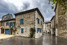
Das Dorf Saou im Département Drôme
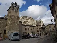
Kirche Sainte-Marie
This article is issued from Wikipedia. The text is licensed under Creative Commons - Attribution - Sharealike. The authors of the article are listed here. Additional terms may apply for the media files, click on images to show image meta data.