Petosse
Petosse ist eine französische Gemeinde im Département Vendée in der Region Pays de la Loire. Sie gehört zum Kanton La Châtaigneraie (bis 2015 Kanton L’Hermenault) im Arrondissement Fontenay-le-Comte.
| Petosse | ||
|---|---|---|
| ||
| Staat | Frankreich | |
| Region | Pays de la Loire | |
| Département (Nr.) | Vendée (85) | |
| Arrondissement | Fontenay-le-Comte | |
| Kanton | La Châtaigneraie | |
| Gemeindeverband | Pays de Fontenay-Vendée | |
| Koordinaten | 46° 29′ N, 0° 54′ W | |
| Höhe | 20–58 m | |
| Fläche | 15,90 km² | |
| Einwohner | 687 (1. Januar 2019) | |
| Bevölkerungsdichte | 43 Einw./km² | |
| Postleitzahl | 85570 | |
| INSEE-Code | 85174 | |
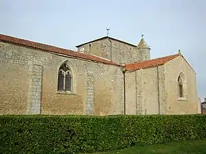 Kirche Saint-Julien | ||

Geographie
Die Gemeinde grenzt im Nordwesten an Pouillé, im Norden an L’Hermenault, im Nordosten an Sérigné, im Osten an Longèves, im Südosten an Auzay, im Süden an Le Langon und im Südwesten an Mouzeuil-Saint-Martin.
Die Autoroute A83 wurde schrittweise eröffnet und erreichte am 28. Oktober 1994 von Boufféré kommend Petosse. Die Fortsetzung bis Oulmes folgte am 21. März 1997.
Bevölkerungsentwicklung
| Jahr | 1962 | 1968 | 1975 | 1982 | 1990 | 1999 | 2004 | 2009 | 2014 |
|---|---|---|---|---|---|---|---|---|---|
| Einwohner | 416 | 423 | 395 | 383 | 432 | 444 | 505 | 586 | 685 |
Sehenswürdigkeiten
- Kirche Saint-Julien, Monument historique
Literatur
- Le Patrimoine des Communes de la Vendée. Flohic Editions, Band 1, Paris 2001, ISBN 2-84234-118-X, S. 374–375.
This article is issued from Wikipedia. The text is licensed under Creative Commons - Attribution - Sharealike. The authors of the article are listed here. Additional terms may apply for the media files, click on images to show image meta data.