Montmirey-la-Ville
Montmirey-la-Ville ist eine in französische Gemeinde mit 171 Einwohnern (Stand 1. Januar 2019) im Département Jura in der Region Bourgogne-Franche-Comté. Sie gehört zum Arrondissement Dole und zum Kanton Authume.
| Montmirey-la-Ville | ||
|---|---|---|

|
| |
| Staat | Frankreich | |
| Region | Bourgogne-Franche-Comté | |
| Département (Nr.) | Jura (39) | |
| Arrondissement | Dole | |
| Kanton | Authume | |
| Gemeindeverband | Jura Nord | |
| Koordinaten | 47° 13′ N, 5° 31′ O | |
| Höhe | 197–320 m | |
| Fläche | 3,99 km² | |
| Einwohner | 171 (1. Januar 2019) | |
| Bevölkerungsdichte | 43 Einw./km² | |
| Postleitzahl | 39290 | |
| INSEE-Code | 39360 | |
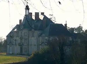 Schloss von Montmirey-la-Ville | ||

Geographie
Die Gemeinde liegt rund 14 Kilometer nördlich von Dole. Die Nachbargemeinden sind Montmirey-le-Château im Nordosten, Moissey im Südosten, Frasne-les-Meulières im Südwesten und Pointre im Nordwesten.
Bevölkerungsentwicklung
| Jahr | 1962 | 1968 | 1975 | 1982 | 1990 | 1999 | 2006 | 2016 | |
|---|---|---|---|---|---|---|---|---|---|
| Einwohner | 180 | 161 | 117 | 165 | 199 | 198 | 184 | 179 | |
| Quellen: Cassini und INSEE | |||||||||
Sehenswürdigkeiten
- Château de Montmirey-la-Ville, Schloss aus dem 19. Jahrhundert – Monument historique[1]
- Prähistorische Siedlung aus der Eisenzeit am Mont-Guérin – Monument historique[2]
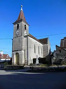
Kirche Saint-Didier
Weblinks
Commons: Montmirey-la-Ville – Sammlung von Bildern, Videos und Audiodateien
Einzelnachweise
- Château de Montmirey-la-Ville in der Base Mérimée des französischen Kulturministeriums (französisch)
- Camp préhistorique du Mont-Guérin in der Base Mérimée des französischen Kulturministeriums (französisch)
This article is issued from Wikipedia. The text is licensed under Creative Commons - Attribution - Sharealike. The authors of the article are listed here. Additional terms may apply for the media files, click on images to show image meta data.