Mont-sous-Vaudrey
Mont-sous-Vaudrey ist eine französische Gemeinde im Département Jura in der Region Bourgogne-Franche-Comté. Sie gehört zum Arrondissement Dole und zum Kanton Mont-sous-Vaudrey, dessen Hauptort sie ist.
| Mont-sous-Vaudrey | ||
|---|---|---|
.svg.png.webp)
|
| |
| Staat | Frankreich | |
| Region | Bourgogne-Franche-Comté | |
| Département (Nr.) | Jura (39) | |
| Arrondissement | Dole | |
| Kanton | Mont-sous-Vaudrey (Hauptort) | |
| Gemeindeverband | Val d’Amour | |
| Koordinaten | 46° 59′ N, 5° 36′ O | |
| Höhe | 211–252 m | |
| Fläche | 15,12 km² | |
| Einwohner | 1.275 (1. Januar 2019) | |
| Bevölkerungsdichte | 84 Einw./km² | |
| Postleitzahl | 39380 | |
| INSEE-Code | 39365 | |
| Website | www.mont-sous-vaudrey.fr | |
Die Nachbargemeinden sind Belmont im Norden, Montbarrey im Nordosten, Vaudrey im Osten, Villers-les-Bois und Oussières im Süden sowie Souvans und Bans im Westen. Bei Mont-sous-Vaudrey zweigt die Départementsstraße D472 von der Route nationale 5 ab.
Bevölkerungsentwicklung
| Jahr | 1962 | 1968 | 1975 | 1982 | 1990 | 1999 | 2008 | 2018 |
|---|---|---|---|---|---|---|---|---|
| Einwohner | 771 | 804 | 844 | 994 | 1099 | 1165 | 1267 | 1277 |
Quellen: Cassini und INSEE
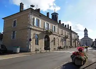
 Ehemaliges Schul- und Rathausgebäude |
 Kirche Mariä Himmelfahrt |
Weblinks
Commons: Mont-sous-Vaudrey – Sammlung von Bildern, Videos und Audiodateien
This article is issued from Wikipedia. The text is licensed under Creative Commons - Attribution - Sharealike. The authors of the article are listed here. Additional terms may apply for the media files, click on images to show image meta data.
