Makwanpur
Der Distrikt Makwanpur (Nepali मकवानपुर जिल्ला Makwānpur Jillā) ist einer von 77 Distrikten Nepals.
| मकवानपुर जिल्ला Distrikt Makwanpur | |
|---|---|
 Lage des Distriktes Makwanpur (rot) in Nepal | |
| Basisdaten | |
| Staat | Nepal |
| Provinz | Bagmati |
| Sitz | Hetauda |
| Fläche | 2426 km² |
| Einwohner | 420.477 (Volkszählung 2011) |
| Dichte | 173 Einwohner pro km² |
| ISO 3166-2 | NP-P3 |
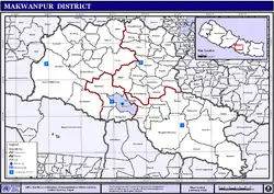 VDCs und Städte (blau) in Makwanpur | |
Der Makwanpur-Distrikt liegt im Inneren Terai in der Verwaltungszone Narayani südlich von Kathmandu. Im Jahre 2001 hatte es 392,604 Einwohner, 2011 waren es 420.477.[1]
Verwaltungsgliederung
Im Distrikt Makwanpur liegen folgende Städte:
Im Distrikt Makwanpur liegen folgende Village Development Committees (VDCs):
- Agara
- Ambhanjyang
- Betini
- Bhaise
- Bharta Pundyadevi
- Bhimphedi
- Budhichaur
- Chhatiwan
- Chitlang
- Dandakharka
- Dhimal
- Gogane
- Handikhola
- Ipa Panchakanya
- Kalikatar
- Kankada
- Khairang
- Kogate
- Kulekhani
- Makwanpurgadhi
- Manahari
- Manthali
- Markhu
- Marta Punchedevi
- Namtar
- Nibuwatar
- Phakhel
- Phaparbadi
- Raigaun
- Raksirang
- Sarikhet Palase
- Shikharpur
- Sisneri Mahadevsthan
- Sripur Chhatiwan
- Sukaura
- Thingan
- Tistung Deurali
Weblinks
Einzelnachweise
- Central Bureau of Statistics, Census 2011: National Report (S. 51–52, Population Total und Area in Sq. Km). (Memento vom 18. April 2013 im Internet Archive) (PDF-Datei; 7,5 MB)
Achham | Arghakhanchi | Baglung | Baitadi | Bajhang | Bajura | Banke | Bara | Bardiya | Bhaktapur | Bhojpur | Chitwan | Dadeldhura | Dailekh | Dang Deukhuri | Darchula | Dhading | Dhankuta | Dhanusha | Dolakha | Dolpa | Doti | Gorkha | Gulmi | Humla | Ilam | Jajarkot | Jhapa | Jumla | Kabhrepalanchok | Kailali | Kalikot | Kanchanpur | Kapilbastu | Kaski | Kathmandu | Khotang | Lalitpur | Lamjung | Mahottari | Makwanpur | Manang | Morang | Mugu | Mustang | Myagdi | Nawalparasi (Bardaghat Susta East) | Nawalparasi (Bardaghat Susta West) | Nuwakot | Okhaldhunga | Palpa | Panchthar | Parbat | Parsa | Pyuthan | Ramechhap | Rasuwa | Rautahat | Rolpa | Rukum East | Rukum West | Rupandehi | Salyan | Sankhuwasabha | Saptari | Sarlahi | Sindhuli | Sindhupalchok | Siraha | Solukhumbu | Sunsari | Surkhet | Syangja | Tanahu | Taplejung | Terhathum | Udayapur