Dailekh
Der Distrikt Dailekh (Nepali लेख जिल्ला) ist einer von 77 Distrikten in Nepal und gehört seit der Verfassung von 2015 zur Provinz Karnali.[1]
| दैलेख जिल्ला Distrikt Dailekh | |
|---|---|
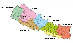 Lage des Distriktes Dailekh (dunkleres Violett) in der Provinz Karnali und in Nepal | |
| Basisdaten | |
| Staat | Nepal |
| Provinz | Karnali |
| Sitz | Dailekh (Narayan) |
| Fläche | 1502 km² |
| Einwohner | 261.770 (Volkszählung 2011) |
| Dichte | 174 Einwohner pro km² |
| ISO 3166-2 | NP-P6 |
| Webauftritt | ddcdailekh.gov.np |
Geschichte
Der Distrikt gehörte bis 2015 zur Verwaltungszone Bheri.
Einwohner
Bei der Volkszählung 2001 hatte der Distrikt Dailekh 225.201; 2011 waren es 261.770.[2]
Verwaltungsgliederung
Städte (Munizipalitäten) im Distrikt Dailekh:[3]
Gaunpalikas (Landgemeinden):
- Thantikandh
- Bhairabi
- Mahabu
- Naumule
- Dungeshwar
- Gurans
- Bhagawatimai
Bis zum Jahr 2017 wurde der Distrikt in die folgenden Village Development Committees (VDCs) unterteilt:
- Awal Parajul
- Bada Bhairab
- Bada Khola
- Baluwatar
- Bansi
- Baraha
- Basantamala
- Belaspur
- Belpata
- Bhawani
- Bindhyabasini
- Bisalla
- Chamunda
- Chauratha
- Dada Parajul
- Gamaudi
- Gauri
- Goganpani
- Jaganath
- Jambukandh
- Kal Bhairab
- Kalika
- Kasikandh
- Katti
- Khadkawada
- Kharigera
- Kusapani
- Lakhandra
- Lakuri
- Lalikhanda
- Lyati Bindraseni
- Mairi Kalikathum
- Malika
- Moheltoli
- Nomule
- Odhari
- Pagnath
- Piladi
- Pipalkot
- Rakam Karnali
- Raniban
- Rawalkot
- Rum
- Salleri
- Santalla
- Saraswati
- Seri
- Sigaudi
- Singasain
- Tilepata
- Tolijaisi
- Toli
Weblinks
Einzelnachweise
- Schedule-4 States, and Districts to be included in the concerned States. – Nepal Law Commission. Abgerufen am 13. Dezember 2018 (englisch).
- Central Bureau of Statistics, Census 2011: National Report (S. 51–52, Population Total und Area in Sq. Km). (Memento vom 25. Mai 2013 im Internet Archive) (PDF; 7,8 MB)
- Nepal: Administrative Unit - State 6 Map | UN Nepal Information Platform. Abgerufen am 1. Januar 2019.
Achham | Arghakhanchi | Baglung | Baitadi | Bajhang | Bajura | Banke | Bara | Bardiya | Bhaktapur | Bhojpur | Chitwan | Dadeldhura | Dailekh | Dang Deukhuri | Darchula | Dhading | Dhankuta | Dhanusha | Dolakha | Dolpa | Doti | Gorkha | Gulmi | Humla | Ilam | Jajarkot | Jhapa | Jumla | Kabhrepalanchok | Kailali | Kalikot | Kanchanpur | Kapilbastu | Kaski | Kathmandu | Khotang | Lalitpur | Lamjung | Mahottari | Makwanpur | Manang | Morang | Mugu | Mustang | Myagdi | Nawalparasi (Bardaghat Susta East) | Nawalparasi (Bardaghat Susta West) | Nuwakot | Okhaldhunga | Palpa | Panchthar | Parbat | Parsa | Pyuthan | Ramechhap | Rasuwa | Rautahat | Rolpa | Rukum East | Rukum West | Rupandehi | Salyan | Sankhuwasabha | Saptari | Sarlahi | Sindhuli | Sindhupalchok | Siraha | Solukhumbu | Sunsari | Surkhet | Syangja | Tanahu | Taplejung | Terhathum | Udayapur