Baglung (Distrikt)
Der Distrikt Baglung (Nepali बागलुङ जिल्ला) ist einer von 77 Distrikten in Nepal.
| बागलुङ जिल्ला Distrikt Baglung | |
|---|---|
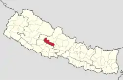 Lage des Distriktes Baglung (rot) in Nepal | |
| Basisdaten | |
| Staat | Nepal |
| Provinz | Gandaki |
| Sitz | Baglung |
| Fläche | 1784 km² |
| Einwohner | 268.613 (Volkszählung 2011[1]) |
| Dichte | 151 Einwohner pro km² |
| ISO 3166-2 | NP-P4 |
 VDCs und Städte (blau) in Baglung | |

Er ist Teil der Verwaltungszone Dhaulagiri in der Entwicklungsregion West. Der Distrikt umfasst das Bergland südlich des Dhaulagiri-Massivs und erstreckt sich südlich des Myagdi Khola und westlich des Kali Gandaki. Der Verwaltungssitz ist in der Stadt Baglung.
Verwaltungsgliederung
Städte (Munizipalitäten) im Distrikt Baglung:
Village Development Committees (VDCs) im Distrikt Baglung:
- Adhikarichaur
- Amalachaur
- Amarbhumi
- Argal
- Arjewa
- Baskot
- Batakachaur
- Bhakunde
- Bhimgithe
- Bhimpokhara
- Bihunkot
- Binamare
- Boharagaun
- Bowang
- Bungadovan
- Burtibang
- Chhisti
- Daga Tundada
- Damek
- Darling
- Devisthan
- Dhamja
- Dhullu Jaidi
- Dhullubaskot
- Dudilavati
- Gwalichaur-Harichaur
- Hatiya
- Heela
- Hudgishir
- Jabdi
- Jaljala
- Kandebas
- Khungkhani
- Khunga
- Kusmishera
- Lekhani
- Malika
- Malma
- Mulpani
- Narayansthan
- Narethanti
- Nisi
- Paiyunthanthap
- Palakot
- Pandavkhani
- Paiyunpata
- Rajkut
- Ranasingkiteni
- Rangkhani
- Rayadanda
- Resha
- Righa
- Salyan
- Sarkuwa
- Singana
- Sisakhani
- Sukhaura
- Sunkhani
- Taman
- Tangram
- Tara
- Tityang
Weblinks
Einzelnachweise
- Central Bureau of Statistics, Census 2011: National Report (S. 51–52, Population Total und Area in Sq. Km). (Memento vom 25. Mai 2013 im Internet Archive) (PDF; 7,8 MB)
Achham | Arghakhanchi | Baglung | Baitadi | Bajhang | Bajura | Banke | Bara | Bardiya | Bhaktapur | Bhojpur | Chitwan | Dadeldhura | Dailekh | Dang Deukhuri | Darchula | Dhading | Dhankuta | Dhanusha | Dolakha | Dolpa | Doti | Gorkha | Gulmi | Humla | Ilam | Jajarkot | Jhapa | Jumla | Kabhrepalanchok | Kailali | Kalikot | Kanchanpur | Kapilbastu | Kaski | Kathmandu | Khotang | Lalitpur | Lamjung | Mahottari | Makwanpur | Manang | Morang | Mugu | Mustang | Myagdi | Nawalparasi (Bardaghat Susta East) | Nawalparasi (Bardaghat Susta West) | Nuwakot | Okhaldhunga | Palpa | Panchthar | Parbat | Parsa | Pyuthan | Ramechhap | Rasuwa | Rautahat | Rolpa | Rukum East | Rukum West | Rupandehi | Salyan | Sankhuwasabha | Saptari | Sarlahi | Sindhuli | Sindhupalchok | Siraha | Solukhumbu | Sunsari | Surkhet | Syangja | Tanahu | Taplejung | Terhathum | Udayapur