Laroque-des-Albères
Laroque-des-Albères (katalanisch La Roca d′Albera) ist eine französische Gemeinde mit 2140 Einwohnern (Stand 1. Januar 2019) im Département Pyrénées-Orientales der Region Okzitanien. Sie gehört zum Arrondissement Céret und zum Kanton Vallespir-Albères.
| Laroque-des-Albères La Roca d′Albera | ||
|---|---|---|
.svg.png.webp)
|
| |
| Staat | Frankreich | |
| Region | Okzitanien | |
| Département (Nr.) | Pyrénées-Orientales (66) | |
| Arrondissement | Céret | |
| Kanton | Vallespir-Albères | |
| Gemeindeverband | Albères, Côte Vermeille et l’Illibéris | |
| Koordinaten | 42° 31′ N, 2° 56′ O | |
| Höhe | 31–1256 m | |
| Fläche | 20,79 km² | |
| Einwohner | 2.140 (1. Januar 2019) | |
| Bevölkerungsdichte | 103 Einw./km² | |
| Postleitzahl | 66740 | |
| INSEE-Code | 66093 | |
| Website | http://www.laroque-des-alberes.fr | |

Laroque liegt am Fuß der Pyrenäen, zum Teil in der Ebene, zum Teil am Berghang. Die höchste Erhebung ist der Pic de Néoulous (Puig Neulos) mit 1256 Metern.
Bevölkerungsentwicklung
- 1962: 853
- 1968: 831
- 1975: 984
- 1982: 1.126
- 1990: 1.508
- 1999: 1.909
- 2007: 1.968
Sehenswürdigkeiten
- Burgruine
- Burg la Roca
- Kirche Saint-Félix et Saint-Blaise (13. Jahrhundert) mit einem Barock-Retabel
- Kapelle Notre-Dame de Tanya (13. Jahrhundert)
- Ruinen der Kapelle Saint-Fructueux de Roca-Vella (wohl 9. Jahrhundert)
- Dolmen Balma del Moro
 Ortsansicht
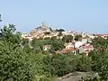
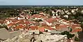 Das Dorf vom Château aus gesehen
.jpg.webp) Das Château, 12. Jh. (von SW)
Das Château, 12. Jh. (von SW)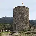 Der Turm des Châteaus (von NW)
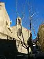 Die Kirche Saint-Félix et Saint-Blaise
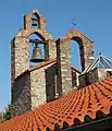 Glockengiebel von Westen gesehen
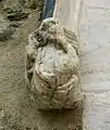 Marmorbüste des hl. Paulus am Portal der Kirche
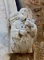 Marmorbüste des hl. Petrus am Portal der Kirche
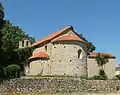 Die Kapelle Notre-Dame de Tanya (Ansicht Ost)
.jpg.webp) Die Kapelle Notre-Dame de Tanya (Ansicht West)
Die Kapelle Notre-Dame de Tanya (Ansicht West)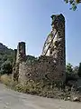 Die Ruinen der Kapelle Saint-Fructueux de Roca-Vella
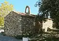 Die romanische Kapelle Saint-Sébastien
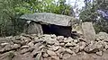 Die Balma del Moro
This article is issued from Wikipedia. The text is licensed under Creative Commons - Attribution - Sharealike. The authors of the article are listed here. Additional terms may apply for the media files, click on images to show image meta data.