Camélas
Camélas ist eine französische Gemeinde mit 460 Einwohnern (Stand 1. Januar 2019) im Département Pyrénées-Orientales in der Region Okzitanien. Sie gehört zum Arrondissement Céret und zum Kanton Les Aspres.
| Camélas | ||
|---|---|---|
| ||
| Staat | Frankreich | |
| Region | Okzitanien | |
| Département (Nr.) | Pyrénées-Orientales (66) | |
| Arrondissement | Céret | |
| Kanton | Les Aspres | |
| Gemeindeverband | Aspres | |
| Koordinaten | 42° 38′ N, 2° 41′ O | |
| Höhe | 118–520 m | |
| Fläche | 12,99 km² | |
| Einwohner | 460 (1. Januar 2019) | |
| Bevölkerungsdichte | 35 Einw./km² | |
| Postleitzahl | 66300 | |
| INSEE-Code | 66033 | |
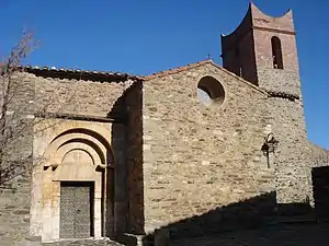 Die Kirche Saint-Fructueux | ||

Geografie
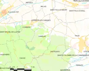
Karte von Camélas
Nachbargemeinden
Nachbargemeinden von Camélas sind Millas im Norden, Saint-Féliu-d‘Aumont im Nordosten, Castelnou im Südosten, Caixas im Südwesten, Corbère im Westen sowie Corbère-les-Cabanes im Nordwesten.
Bevölkerungsentwicklung
| Jahr | 1962 | 1968 | 1975 | 1982 | 1990 | 1999 | 2013 |
| Einwohner | 313 | 289 | 268 | 308 | 323 | 396 | 428 |
Sehenswürdigkeiten
- Kirche Saint-Fructueux (Monument historique)
- Kapelle Saint-Martin in La Roca
- Kirche Saint-Michel in Vallcrosa
- Dolmen Caixeta (Monument historique)
This article is issued from Wikipedia. The text is licensed under Creative Commons - Attribution - Sharealike. The authors of the article are listed here. Additional terms may apply for the media files, click on images to show image meta data.