Montbolo
| Montbolo | ||
|---|---|---|
.svg.png.webp)
|
| |
| Staat | Frankreich | |
| Region | Okzitanien | |
| Département (Nr.) | Pyrénées-Orientales (66) | |
| Arrondissement | Céret | |
| Kanton | Le Canigou | |
| Gemeindeverband | Haut Vallespir | |
| Koordinaten | 42° 29′ N, 2° 39′ O | |
| Höhe | 240–1323 m | |
| Fläche | 22,00 km² | |
| Einwohner | 177 (1. Januar 2019) | |
| Bevölkerungsdichte | 8 Einw./km² | |
| Postleitzahl | 66110 | |
| INSEE-Code | 66113 | |
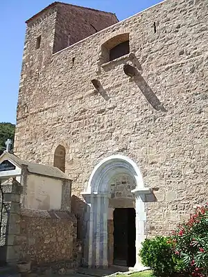 Kirche Saint-André | ||

Montbolo ist eine französische Gemeinde mit 177 Einwohnern (Stand 1. Januar 2019) im Département Pyrénées-Orientales in der Region Okzitanien. Sie gehört zum Arrondissement Céret und zum Kanton Le Canigou.
Nachbargemeinden
Nachbargemeinden von Montbolo sind Saint-Marsal im Norden, Taillet im Nordosten, Reynès im Osten, Amélie-les-Bains-Palalda im Südosten, Arles-sur-Tech im Süden, Corsavy im Westen und Taulis im Nordwesten.
Bevölkerungsentwicklung
| Jahr | 1962 | 1968 | 1975 | 1982 | 1990 | 1999 | 2013 |
| Einwohner | 139 | 124 | 92 | 105 | 133 | 145 | 182 |
Sehenswürdigkeiten
- romanische Kirche Saint-André
- Dolmen Caixa von Rotllan
This article is issued from Wikipedia. The text is licensed under Creative Commons - Attribution - Sharealike. The authors of the article are listed here. Additional terms may apply for the media files, click on images to show image meta data.