La Guérinière
La Guérinière ist eine französische Gemeinde mit 1.320 Einwohnern (Stand: 1. Januar 2019) im Département Vendée der Region Pays de la Loire. La Guérinière gehört zum Arrondissement Les Sables-d’Olonne und zum Kanton Saint-Jean-de-Monts (bis 2015: Kanton Noirmoutier-en-l’Île). Die Einwohner werden Guernerins genannt.
| La Guérinière | ||
|---|---|---|
| ||
| Staat | Frankreich | |
| Region | Pays de la Loire | |
| Département (Nr.) | Vendée (85) | |
| Arrondissement | Les Sables-d’Olonne | |
| Kanton | Saint-Jean-de-Monts | |
| Gemeindeverband | L’Île de Noirmoutier | |
| Koordinaten | 46° 58′ N, 2° 14′ W | |
| Höhe | 0–20 m | |
| Fläche | 7,90 km² | |
| Einwohner | 1.320 (1. Januar 2019) | |
| Bevölkerungsdichte | 167 Einw./km² | |
| Postleitzahl | 85680 | |
| INSEE-Code | 85106 | |
| Website | http://www.la-gueriniere.fr/ | |
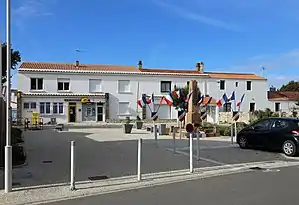 La Guérinière: Place de la Mairie | ||

Geografie
La Guérinière liegt inmitten der Île de Noirmoutier im Atlantik. Im Norden und Nordwesten von La Guérinière liegt die Nachbargemeinde L’Épine und im Osten und Südosten die Gemeinde Barbâtre.
| Bevölkerungsentwicklung | ||||||||
|---|---|---|---|---|---|---|---|---|
| Jahr | 1962 | 1968 | 1975 | 1982 | 1990 | 1999 | 2006 | 2012 |
| Einwohner | 1.295 | 1.162 | 1.312 | 1.305 | 1.402 | 1.486 | 1.543 | 1.430 |
| Quelle: Cassini und INSEE | ||||||||
Sehenswürdigkeiten
- Kirche Mariä Geburt (Église de la Nativité-de-la-Sainte-Vierge)
- Strand und Salzwiesen
Literatur
- Le Patrimoine des Communes de la Vendée. Flohic Editions, Band 2, Paris 2001, ISBN 2-84234-118-X, S. 685–686.
Weblinks
Commons: La Guérinière – Sammlung von Bildern, Videos und Audiodateien
This article is issued from Wikipedia. The text is licensed under Creative Commons - Attribution - Sharealike. The authors of the article are listed here. Additional terms may apply for the media files, click on images to show image meta data.