La Chapelle-Aubareil
La Chapelle-Aubareil (okzitanisch: La Capèla Albarèlh) ist eine Gemeinde mit 533 Einwohnern (Stand: 1. Januar 2019) in Frankreich im Département Dordogne und in der Region Nouvelle-Aquitaine. Die Gemeinde gehört zum Arrondissement Sarlat-la-Canéda und zum Kanton Vallée de l’Homme (bis 2015: Kanton Montignac).
| La Chapelle-Aubareil La Capèla Albarèlh | ||
|---|---|---|
| ||
| Staat | Frankreich | |
| Region | Nouvelle-Aquitaine | |
| Département (Nr.) | Dordogne (24) | |
| Arrondissement | Sarlat-la-Canéda | |
| Kanton | Vallée de l’Homme | |
| Gemeindeverband | Vallée de l’Homme | |
| Koordinaten | 45° 1′ N, 1° 11′ O | |
| Höhe | 109–288 m | |
| Fläche | 20,32 km² | |
| Einwohner | 533 (1. Januar 2019) | |
| Bevölkerungsdichte | 26 Einw./km² | |
| Postleitzahl | 24290 | |
| INSEE-Code | 24106 | |
| Website | https://www.la-chapelle-aubareil.fr/ | |
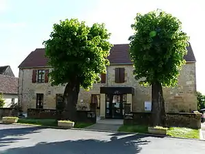 Rathaus (Mairie) von La Chapelle-Aubareil | ||

Geografie
La Chapelle-Aubareil liegt etwa 40 Kilometer südöstlich von Périgueux im Périgord. Umgeben wird La Chapelle-Aubareil von den Nachbargemeinden Montignac-Lascaux im Norden und Nordwesten, Coly-Saint-Amand im Nordosten, Saint-Geniès im Osten, Marcillac-Saint-Quentin im Süden, Tamniès im Südwesten sowie Valojoulx im Westen.
Bevölkerungsentwicklung
| Jahr | 1962 | 1968 | 1975 | 1982 | 1990 | 1999 | 2006 | 2013 |
| Einwohner | 386 | 333 | 280 | 308 | 330 | 373 | 439 | 516 |
| Quelle: Cassini und INSEE | ||||||||
Sehenswürdigkeiten
- Kirche Saint-Loup aus dem 17. Jahrhundert
- Turm von Le Bareil aus dem 13. Jahrhundert
- Herrenhaus L'Air aus dem 18./19. Jahrhundert
- Altes Rathaus
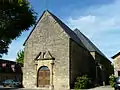 Kirche Saint-Loup
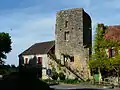 Turm Le Bareil
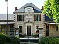 Altes Rathaus von La Chapelle-Aubareil
This article is issued from Wikipedia. The text is licensed under Creative Commons - Attribution - Sharealike. The authors of the article are listed here. Additional terms may apply for the media files, click on images to show image meta data.