Florimont-Gaumier
Florimont-Gaumier (okzitanisch: Florimont e Gaumièr) ist eine französische Gemeinde mit 147 Einwohnern (Stand: 1. Januar 2019) im Département Dordogne in Nouvelle-Aquitaine (vor 2016 Aquitaine). Sie gehört zum Arrondissement Sarlat-la-Canéda und zum Kanton Vallée Dordogne (bis 2015 Domme). Die Einwohner werden Florimontois genannt.
| Florimont-Gaumier Florimont e Gaumièr | ||
|---|---|---|
| ||
| Staat | Frankreich | |
| Region | Nouvelle-Aquitaine | |
| Département (Nr.) | Dordogne (24) | |
| Arrondissement | Sarlat-la-Canéda | |
| Kanton | Vallée Dordogne | |
| Gemeindeverband | Domme Villefranche-du-Périgord | |
| Koordinaten | 44° 42′ N, 1° 14′ O | |
| Höhe | 116–288 m | |
| Fläche | 9,33 km² | |
| Einwohner | 147 (1. Januar 2019) | |
| Bevölkerungsdichte | 16 Einw./km² | |
| Postleitzahl | 24250 | |
| INSEE-Code | 24184 | |
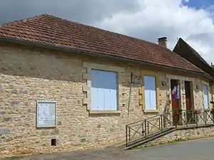 Rathaus (Mairie) von Florimont-Gaumier | ||

Geografie
Florimont-Gaumier liegt etwa 57 Kilometer ostsüdöstlich von Bergerac. Nachbargemeinden sind Bouzic im Norden und Westen, Saint-Martial-de-Nabirat im Norden und Nordosten, Saint-Aubin-de-Nabirat im Nordosten, Salviac im Süden und Osten sowie Campagnac-lès-Quercy im Südwesten.
Bevölkerungsentwicklung
| Jahr | 1962 | 1968 | 1975 | 1982 | 1990 | 1999 | 2006 | 2013 |
|---|---|---|---|---|---|---|---|---|
| Einwohner | 262 | 252 | 230 | 181 | 164 | 132 | 140 | 142 |
| Quelle: Cassini und INSEE | ||||||||
Sehenswürdigkeiten
- Kirche Saint-Blaise in Florimont aus dem 12. Jahrhundert, seit 1977 Monument historique
- Kirche Saint-Pierre-ès-Liens in Gaumier aus dem 12. Jahrhundert, seit 1974 Monument historique
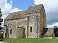 Kirche Saint-Blaise
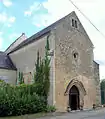 Kirche Saint-Pierre-ès-Liens
This article is issued from Wikipedia. The text is licensed under Creative Commons - Attribution - Sharealike. The authors of the article are listed here. Additional terms may apply for the media files, click on images to show image meta data.