Kanton Darnétal
Der Kanton Darnétal ist ein französischer Wahlkreis im Arrondissement Rouen im Département Seine-Maritime und in der Region Normandie; sein Hauptort ist Darnétal. Vertreter im Generalrat des Départements ist seit 2011 Jacques-Antoine Philippe (PS).
| Kanton Darnétal | |
|---|---|
| Region | Normandie |
| Département | Seine-Maritime |
| Arrondissement | Rouen |
| Hauptort | Darnétal |
| Einwohner | 38.387 (1. Jan. 2019) |
| Bevölkerungsdichte | 439 Einw./km² |
| Fläche | 87,47 km² |
| Gemeinden | 15 |
| INSEE-Code | 7606 |
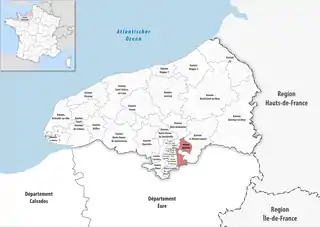 Lage des Kantons Darnétal im Département Seine-Maritime | |
Der Kanton Darnétal ist 87,29 km² groß und hat (2019) 38.387 Einwohner, was einer Bevölkerungsdichte von 440 Einwohnern pro km² entspricht.
Gemeinden
Der Kanton besteht aus 15 Gemeinden mit insgesamt 38.387 Einwohnern (Stand: 1. Januar 2019) auf einer Gesamtfläche von 87,47 km²:
| Gemeinde | Einwohner 1. Januar 2019 |
Fläche km² |
Dichte Einw./km² |
Code INSEE |
Postleitzahl |
|---|---|---|---|---|---|
| Amfreville-la-Mi-Voie | 3.306 | 3,99 | 829 | 76005 | 76920 |
| Belbeuf | 2.235 | 6,48 | 345 | 76069 | 76240 |
| Bonsecours | 6.479 | 3,71 | 1.746 | 76103 | 76240 |
| Darnétal | 9.788 | 4,88 | 2.006 | 76212 | 76160 |
| Fontaine-sous-Préaux | 541 | 3,56 | 152 | 76273 | 76160 |
| Gouy | 888 | 5,00 | 178 | 76313 | 76520 |
| Les Authieux-sur-le-Port-Saint-Ouen | 1.261 | 4,53 | 278 | 76039 | 76520 |
| Quévreville-la-Poterie | 1.025 | 4,73 | 217 | 76514 | 76520 |
| Roncherolles-sur-le-Vivier | 1.209 | 5,35 | 226 | 76536 | 76160 |
| Saint-Aubin-Celloville | 1.176 | 6,76 | 174 | 76558 | 76520 |
| Saint-Aubin-Épinay | 1.024 | 9,86 | 104 | 76560 | 76160 |
| Saint-Jacques-sur-Darnétal | 3.045 | 16,74 | 182 | 76591 | 76160 |
| Saint-Léger-du-Bourg-Denis | 3.599 | 2,86 | 1.258 | 76599 | 76160 |
| Saint-Martin-du-Vivier | 1.660 | 5,05 | 329 | 76617 | 76160 |
| Ymare | 1.151 | 3,97 | 290 | 76753 | 76520 |
| Kanton Darnétal | 38.387 | 87,47 | 439 | 7606 | – |
Bis zur Neuordnung bestand der Kanton Darnétal aus den 19 Gemeinden Auzouville-sur-Ry, Bois-d’Ennebourg, Bois-l’Évêque, Darnétal, Elbeuf-sur-Andelle, Fontaine-sous-Préaux, Grainville-sur-Ry, Le Héron, Martainville-Épreville, Préaux, Roncherolles-sur-le-Vivier, Ry, Saint-Aubin-Épinay, Saint-Denis-le-Thiboult, Saint-Jacques-sur-Darnétal, Saint-Léger-du-Bourg-Denis, Saint-Martin-du-Vivier, Servaville-Salmonville und La Vieux-Rue. Sein Zuschnitt entsprach einer Fläche von 148,23 km2.
Bevölkerungsentwicklung
| 1962 | 1968 | 1975 | 1982 | 1990 | 1999 | 2010 |
|---|---|---|---|---|---|---|
| 18.122 | 19.922 | 22.365 | 23.611 | 25.234 | 25.812 | 27.830 |