Kanton Damigny
Der Kanton Damigny ist ein französischer Wahlkreis im Arrondissement Alençon, im Département Orne und in der Region Normandie; sein Hauptort ist Damigny.
| Kanton Damigny | |
|---|---|
| Region | Normandie |
| Département | Orne |
| Arrondissement | Alençon |
| Hauptort | Damigny |
| Einwohner | 13.649 (1. Jan. 2019) |
| Bevölkerungsdichte | 79 Einw./km² |
| Fläche | 173,17 km² |
| Gemeinden | 16 |
| INSEE-Code | 6110 |
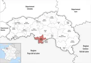 Lage des Kantons Damigny im Département Orne | |
Gemeinden
Der Kanton besteht aus 16 Gemeinden mit insgesamt 13.649 Einwohnern (Stand: 1. Januar 2019) auf einer Gesamtfläche von 173,17 km²:
| Gemeinde | Einwohner 1. Januar 2019 |
Fläche km² |
Dichte Einw./km² |
Code INSEE |
Postleitzahl |
|---|---|---|---|---|---|
| Colombiers | 329 | 12,21 | 27 | 61111 | 61250 |
| Condé-sur-Sarthe | 2.490 | 8,47 | 294 | 61117 | 61250 |
| Cuissai | 410 | 8,99 | 46 | 61141 | 61250 |
| Damigny | 2.464 | 4,86 | 507 | 61143 | 61250 |
| Gandelain | 418 | 14,95 | 28 | 61182 | 61420 |
| Héloup | 902 | 12,82 | 70 | 61203 | 61250 |
| La Ferrière-Bochard | 746 | 10,82 | 69 | 61165 | 61420 |
| Lalacelle | 275 | 13,41 | 21 | 61213 | 61320 |
| La Roche-Mabile | 160 | 5,19 | 31 | 61350 | 61420 |
| Lonrai | 1.129 | 6,17 | 183 | 61234 | 61250 |
| Mieuxcé | 611 | 10,31 | 59 | 61279 | 61250 |
| Pacé | 420 | 7,57 | 55 | 61321 | 61250 |
| Saint-Céneri-le-Gérei | 115 | 3,85 | 30 | 61372 | 61250 |
| Saint-Denis-sur-Sarthon | 1.128 | 13,90 | 81 | 61382 | 61420 |
| Saint-Nicolas-des-Bois | 284 | 25,34 | 11 | 61433 | 61250 |
| Valframbert | 1.768 | 14,31 | 124 | 61497 | 61250 |
| Kanton Damigny | 13.649 | 173,17 | 79 | 6110 | – |
This article is issued from Wikipedia. The text is licensed under Creative Commons - Attribution - Sharealike. The authors of the article are listed here. Additional terms may apply for the media files, click on images to show image meta data.