Kanton Tourouvre au Perche
Der Kanton Tourouvre au Perche (früher Tourouvre) ist ein französischer Wahlkreis im Arrondissement Mortagne-au-Perche im Département Orne in der Region Normandie; sein Hauptort ist Tourouvre au Perche, Vertreter im Generalrat des Départements ist seit 1994 (wiedergewählt 2008) Guy Monhée.
| Kanton Tourouvre au Perche | |
|---|---|
| Region | Normandie |
| Département | Orne |
| Arrondissement | Mortagne-au-Perche |
| Hauptort | Tourouvre au Perche |
| Einwohner | 12.807 (1. Jan. 2019) |
| Bevölkerungsdichte | 22 Einw./km² |
| Fläche | 571,99 km² |
| Gemeinden | 23 |
| INSEE-Code | 6120 |
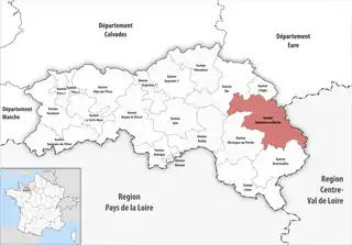 Lage des Kantons Tourouvre au Perche im Département Orne | |
Gemeinden
Der Kanton besteht aus 23 Gemeinden mit insgesamt 12.807 Einwohnern (Stand: 1. Januar 2019) auf einer Gesamtfläche von 571,99 km²:
| Gemeinde | Einwohner 1. Januar 2019 |
Fläche km² |
Dichte Einw./km² |
Code INSEE |
Postleitzahl |
|---|---|---|---|---|---|
| Auguaise | 217 | 2,20 | 99 | 61012 | 61270 |
| Beaulieu | 204 | 18,07 | 11 | 61034 | 61190 |
| Bizou | 133 | 9,19 | 14 | 61046 | 61290 |
| Bonnefoi | 188 | 5,45 | 34 | 61052 | 61270 |
| Bonsmoulins | 235 | 7,59 | 31 | 61053 | 61380 |
| Brethel | 166 | 3,01 | 55 | 61060 | 61270 |
| Charencey | 784 | 45,81 | 17 | 61429 | 61190 |
| Crulai | 847 | 22,79 | 37 | 61140 | 61300 |
| Irai | 617 | 15,04 | 41 | 61208 | 61190 |
| La Chapelle-Viel | 282 | 45,81 | 6 | 61100 | 61270 |
| La Ferrière-au-Doyen | 160 | 22,60 | 7 | 61162 | 61380 |
| La Ventrouze | 124 | 7,13 | 17 | 61500 | 61190 |
| Le Mage | 223 | 25,52 | 9 | 61242 | 61290 |
| Le Ménil-Bérard | 73 | 7,49 | 10 | 61259 | 61270 |
| Le Pas-Saint-l’Homer | 128 | 9,41 | 14 | 61323 | 61290 |
| Les Aspres | 617 | 23,47 | 26 | 61422 | 61270 |
| Les Genettes | 194 | 6,54 | 30 | 61187 | 61270 |
| Les Menus | 238 | 11,85 | 20 | 61274 | 61290 |
| L’Hôme-Chamondot | 252 | 16,06 | 16 | 61206 | 61290 |
| Longny les Villages | 2.985 | 152,80 | 20 | 61230 | 61290 |
| Moulins-la-Marche | 732 | 13,20 | 55 | 61297 | 61380 |
| Saint-Hilaire-sur-Risle | 316 | 6,69 | 47 | 61406 | 61270 |
| Tourouvre au Perche | 3.092 | 94,27 | 33 | 61491 | 61190 |
| Kanton Tourouvre au Perche | 12.807 | 571,99 | 22 | 6120 | – |
Bis zur Neuordnung bestand der Kanton Tourouvre au Perche aus den 15 Gemeinden Autheuil, Beaulieu, Bivilliers, Bresolettes, Bubertré, Champs, Lignerolles, Moussonvilliers, Normandel, La Poterie-au-Perche, Prépotin, Randonnai, Saint-Maurice-lès-Charencey, Tourouvre und La Ventrouze. Sein Zuschnitt entsprach einer Fläche von 164,44 km2.
Veränderungen im Gemeindebestand seit der landesweiten Neuordnung der Kantone
2018:
- Fusion Moussonvilliers, Normandel und Saint-Maurice-lès-Charencey → Charencey
2016:
- Fusion La Lande-sur-Eure, Longny-au-Perche, Malétable, Marchainville, Monceaux-au-Perche, Moulicent, Neuilly-sur-Eure und Saint-Victor-de-Réno → Longny les Villages
- Fusion Autheuil, Bivilliers, Bresolettes, Bubertré, Champs, La Poterie-au-Perche, Lignerolles, Prépotin, Randonnai und Tourouvre → Tourouvre au Perche
Bevölkerungsentwicklung
| 1962 | 1968 | 1975 | 1982 | 1990 | 1999 | 2006 |
|---|---|---|---|---|---|---|
| 4403 | 4876 | 5175 | 4826 | 4455 | 4363 | 4547 |