Kanton Cerizay
Der Kanton Cerizay ist ein französischer Wahlkreis in den Arrondissements Bressuire und Parthenay im Département Deux-Sèvres in der Region Nouvelle-Aquitaine; sein Hauptort ist Cerizay. Vertreter im Generalrat des Départements sind seit 2015 Thierry Marolleau und Sylvie Renaudin (beide DVD).
| Kanton Cerizay | |
|---|---|
| Region | Nouvelle-Aquitaine |
| Département | Deux-Sèvres |
| Arrondissement | Bressuire (Zehn Gemeinden) Parthenay (Acht Gemeinden) |
| Hauptort | Cerizay |
| Einwohner | 26.141 (1. Jan. 2019) |
| Bevölkerungsdichte | 55 Einw./km² |
| Fläche | 471,47 km² |
| Gemeinden | 18 |
| INSEE-Code | 7904 |
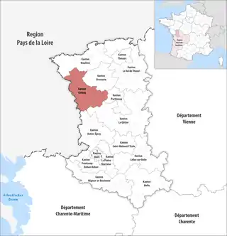 Lage des Kantons Cerizay im Département Deux-Sèvres | |
Gemeinden
Der Kanton besteht aus 18 Gemeinden mit insgesamt 26.141 Einwohnern (Stand: 1. Januar 2019) auf einer Gesamtfläche von 471,47 km²:
| Gemeinde | Einwohner 1. Januar 2019 |
Fläche km² |
Dichte Einw./km² |
Code INSEE |
Postleitzahl | Arrondissement |
|---|---|---|---|---|---|---|
| Bretignolles | 589 | 13,11 | 45 | 79050 | 79140 | Bressuire |
| Cerizay | 4.764 | 18,89 | 252 | 79062 | 79140 | Bressuire |
| Chanteloup | 1.012 | 20,69 | 49 | 79069 | 79320 | Parthenay |
| Cirières | 947 | 17,16 | 55 | 79091 | 79140 | Bressuire |
| Clessé | 952 | 29,20 | 33 | 79094 | 79350 | Parthenay |
| Combrand | 1.144 | 24,58 | 47 | 79096 | 79140 | Bressuire |
| Courlay | 2.421 | 29,35 | 82 | 79103 | 79440 | Bressuire |
| L’Absie | 1.052 | 13,19 | 80 | 79001 | 79240 | Parthenay |
| La Chapelle-Saint-Laurent | 2.034 | 28,79 | 71 | 79076 | 79430 | Parthenay |
| La Forêt-sur-Sèvre | 2.311 | 56,00 | 41 | 79123 | 79380 | Bressuire |
| Largeasse | 732 | 30,34 | 24 | 79147 | 79240 | Parthenay |
| Le Pin | 1.047 | 18,99 | 55 | 79210 | 79140 | Bressuire |
| Moncoutant-sur-Sèvre | 5.057 | 93,19 | 54 | 79179 | 79240, 79320, 79380 | Bressuire |
| Montravers | 373 | 10,08 | 37 | 79183 | 79140 | Bressuire |
| Neuvy-Bouin | 492 | 25,57 | 19 | 79190 | 79130 | Parthenay |
| Saint-André-sur-Sèvre | 652 | 19,81 | 33 | 79236 | 79380 | Bressuire |
| Saint-Paul-en-Gâtine | 441 | 15,39 | 29 | 79286 | 79240 | Parthenay |
| Trayes | 121 | 7,14 | 17 | 79332 | 79240 | Parthenay |
| Kanton Cerizay | 26.141 | 471,47 | 55 | 7904 | – | – |
Bis zur landesweiten Neuordnung der französischen Kantone im März 2015 gehörte zum Kanton Cerizay die zehn Gemeinden Bretignolles, Cerizay, Cirières, Combrand, Courlay, La Forêt-sur-Sèvre, Le Pin, Montravers, Saint-André-sur-Sèvre und Saint-Jouin-de-Milly. Sein Zuschnitt entsprach einer Fläche von 214,39 km2. Er besaß vor 2015 einen anderen INSEE-Code als heute, nämlich 7907.
Veränderungen im Gemeindebestand seit der landesweiten Neuordnung der Kantone
2019: Fusion La Chapelle-Saint-Étienne, Le Breuil-Bernard, Moncoutant, Moutiers-sous-Chantemerle, Pugny und Saint-Jouin-de-Milly → Moncoutant-sur-Sèvre