Kanton Mauléon
Der Kanton Mauléon ist ein französischer Wahlkreis im Arrondissement Bressuire im Département Deux-Sèvres in der Region Nouvelle-Aquitaine; sein Hauptort ist Mauléon. Vertreter im Generalrat des Départements ist seit 2009 Philippe Brémond (DVD).
| Kanton Mauléon | |
|---|---|
| Region | Nouvelle-Aquitaine |
| Département | Deux-Sèvres |
| Arrondissement | Bressuire |
| Hauptort | Mauléon |
| Einwohner | 23.638 (1. Jan. 2019) |
| Bevölkerungsdichte | 43 Einw./km² |
| Fläche | 546,87 km² |
| Gemeinden | 10 |
| INSEE-Code | 7907 |
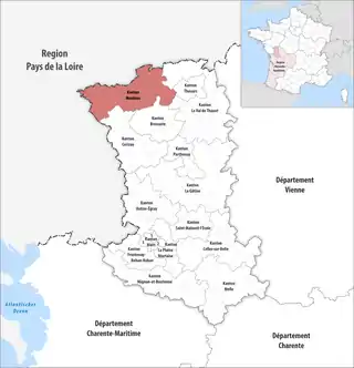 Lage des Kantons Mauléon im Département Deux-Sèvres | |
Gemeinden
Der Kanton besteht aus zehn Gemeinden mit insgesamt 23.638 Einwohnern (Stand: 1. Januar 2019) auf einer Gesamtfläche von 546,87 km²:
| Gemeinde | Einwohner 1. Januar 2019 |
Fläche km² |
Dichte Einw./km² |
Code INSEE |
Postleitzahl |
|---|---|---|---|---|---|
| Argentonnay | 3.183 | 117,61 | 27 | 79013 | 79150 |
| Genneton | 317 | 27,68 | 11 | 79132 | 79150 |
| La Petite-Boissière | 630 | 13,21 | 48 | 79207 | 79700 |
| Mauléon | 8.578 | 122,43 | 70 | 79079 | 79700 |
| Nueil-les-Aubiers | 5.536 | 100,92 | 55 | 79195 | 79250 |
| Saint-Amand-sur-Sèvre | 1.408 | 32,63 | 43 | 79235 | 79700 |
| Saint-Aubin-du-Plain | 540 | 14,18 | 38 | 79238 | 79300 |
| Saint Maurice Étusson | 883 | 57,33 | 15 | 79280 | 79150 |
| Saint-Pierre-des-Échaubrognes | 1.444 | 29,26 | 49 | 79289 | 79700 |
| Voulmentin | 1.119 | 31,62 | 35 | 79242 | 79150 |
| Kanton Mauléon | 23.638 | 546,87 | 43 | 7907 | – |
Bis zur landesweiten Neuordnung der französischen Kantone im März 2015 gehörte zum Kanton Mauléon die fünf Gemeinden La Petite-Boissière, Mauléon, Nueil-les-Aubiers, Saint-Amand-sur-Sèvre und Saint-Pierre-des-Échaubrognes. Sein Zuschnitt entsprach einer Fläche von 293,67 km2. Er besaß vor 2015 einen anderen INSEE-Code als heute, nämlich 7909.
Veränderungen im Gemeindebestand seit der landesweiten Neuordnung der Kantone
2016:
- Fusion Argenton-les-Vallées, La Chapelle-Gaudin (Kanton Bressuire), La Coudre, Le Breuil-sous-Argenton, Moutiers-sous-Argenton und Ulcot → Argentonnay
- Fusion Étusson und Saint-Maurice-la-Fougereuse → Saint Maurice Étusson
This article is issued from Wikipedia. The text is licensed under Creative Commons - Attribution - Sharealike. The authors of the article are listed here. Additional terms may apply for the media files, click on images to show image meta data.