Kanton Armentières
Der Kanton Armentières ist ein französischer Wahlkreis im Arrondissement Lille und im Département Nord.
| Kanton Armentières | |
|---|---|
| Region | Hauts-de-France |
| Département | Nord |
| Arrondissement | Lille |
| Hauptort | Armentières |
| Einwohner | 66.027 (1. Jan. 2019) |
| Bevölkerungsdichte | 821 Einw./km² |
| Fläche | 80,43 km² |
| Gemeinden | 11 |
| INSEE-Code | 5904 |
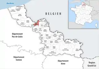 Lage des Kantons Armentières im Département Nord | |
Gemeinden
Der Kanton besteht aus elf Gemeinden mit insgesamt 66.027 Einwohnern (Stand: 1. Januar 2019) auf einer Gesamtfläche von 80,43 km²:
| Gemeinde | Einwohner 1. Januar 2019 |
Fläche km² |
Dichte Einw./km² |
Code INSEE |
Postleitzahl |
|---|---|---|---|---|---|
| Armentières | 24.909 | 6,23 | 3.998 | 59017 | 59280 |
| Bois-Grenier | 1.739 | 7,47 | 233 | 59088 | 59280 |
| Capinghem | 2.537 | 1,84 | 1.379 | 59128 | 59160 |
| La Chapelle-d’Armentières | 8.577 | 10,74 | 799 | 59143 | 59930 |
| Deûlémont | 1.818 | 9,96 | 183 | 59173 | 59890 |
| Erquinghem-Lys | 5.316 | 9,20 | 578 | 59202 | 59193 |
| Frelinghien | 2.447 | 11,29 | 217 | 59252 | 59236 |
| Houplines | 7.782 | 11,41 | 682 | 59317 | 59116 |
| Pérenchies | 8.542 | 3,05 | 2.801 | 59457 | 59840 |
| Prémesques | 2.123 | 5,08 | 418 | 59470 | 59840 |
| Warneton | 237 | 4,16 | 57 | 59643 | 59560 |
| Kanton Armentières | 66.027 | 80,43 | 821 | 5904 | – |
This article is issued from Wikipedia. The text is licensed under Creative Commons - Attribution - Sharealike. The authors of the article are listed here. Additional terms may apply for the media files, click on images to show image meta data.