Jouy-le-Potier
| Jouy-le-Potier | ||
|---|---|---|
.svg.png.webp)
|
| |
| Staat | Frankreich | |
| Region | Centre-Val de Loire | |
| Département (Nr.) | Loiret (45) | |
| Arrondissement | Orléans | |
| Kanton | Beaugency | |
| Gemeindeverband | Portes de Sologne | |
| Koordinaten | 47° 45′ N, 1° 49′ O | |
| Höhe | 94–119 m | |
| Fläche | 50,74 km² | |
| Einwohner | 1.440 (1. Januar 2019) | |
| Bevölkerungsdichte | 28 Einw./km² | |
| Postleitzahl | 45370 | |
| INSEE-Code | 45175 | |
| Website | https://jouy-le-potier.fr/ | |

Jouy-le-Potier ist eine französische Gemeinde mit 1.440 Einwohnern (Stand: 1. Januar 2019) im Département Loiret in der Region Centre-Val de Loire. Sie gehört zum Arrondissement Orléans und zum Kanton Beaugency (bis 2015: Kanton Cléry-Saint-André). Die Einwohner werden Joviciens genannt.
Geographie
Jouy-le-Potier liegt etwa 18 Kilometer südsüdwestlich von Orléans in der Sologne. Umgeben wird Jouy-le-Potier von den Nachbargemeinden Cléry-Saint-André im Norden, Mézières-lez-Cléry im Norden und Nordosten, Ardon im Osten und Nordosten, La Ferté-Saint-Aubin im Südosten, Ligny-le-Ribault im Süden, Lailly-en-Val im Westen sowie Dry im Nordwesten.
Bevölkerungsentwicklung
| 1962 | 1968 | 1975 | 1982 | 1990 | 1999 | 2006 | 2018 |
|---|---|---|---|---|---|---|---|
| 630 | 551 | 638 | 856 | 1187 | 1325 | 1351 | 1357 |
| Quellen: Cassini und INSEE | |||||||
Sehenswürdigkeiten
- Kirche Saint-Pierre, Monument historique seit 1935
- Schloss Le Lude, seit 2002 Monument historique
- mehrere Schlösser aus dem 19. Jahrhundert
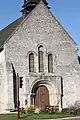 Kirche Saint-Pierre
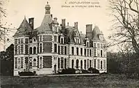 alte Postkarte des Schlosses Villefallier
Weblinks
Commons: Jouy-le-Potier – Sammlung von Bildern, Videos und Audiodateien
This article is issued from Wikipedia. The text is licensed under Creative Commons - Attribution - Sharealike. The authors of the article are listed here. Additional terms may apply for the media files, click on images to show image meta data.