Jars (Cher)
| Jars | ||
|---|---|---|
.svg.png.webp)
|
| |
| Staat | Frankreich | |
| Region | Centre-Val de Loire | |
| Département (Nr.) | Cher (18) | |
| Arrondissement | Bourges | |
| Kanton | Sancerre | |
| Gemeindeverband | Pays Fort Sancerrois Val de Loire | |
| Koordinaten | 47° 24′ N, 2° 41′ O | |
| Höhe | 204–364 m | |
| Fläche | 38,06 km² | |
| Einwohner | 503 (1. Januar 2019) | |
| Bevölkerungsdichte | 13 Einw./km² | |
| Postleitzahl | 18260 | |
| INSEE-Code | 18117 | |
| Website | http://www.jars-cher.fr/ | |

Jars ist eine französische Gemeinde mit 503 Einwohnern (Stand: 1. Januar 2019) im Département Cher in der Region Centre-Val de Loire. Sie gehört zum Arrondissement Bourges und zum Kanton Sancerre (bis 2015: Kanton Vailly-sur-Sauldre).
Geographie
Jars liegt in Zentralfrankreich, etwa 39 Kilometer nordöstlich von Bourges am Sauldre. Umgeben wird Jars von den Nachbargemeinden Villegenon im Norden und Nordwesten, Thou im Norden, Sury-ès-Bois im Norden und Nordosten, Assigny im Nordosten, Subligny im Osten, Menetou-Râtel im Südosten, Le Noyer im Süden, La Chapelotte im Südwesten sowie Ivoy-le-Pré im Westen und Südwesten.
Bevölkerungsentwicklung
| Jahr | 1962 | 1968 | 1975 | 1982 | 1990 | 1999 | 2006 | 2013 |
| Einwohner | 645 | 596 | 552 | 554 | 522 | 505 | 490 | 525 |
| Quelle: Cassini und INSEE | ||||||||
Sehenswürdigkeiten
- Kirche Saint-Agnan aus dem 15. Jahrhundert, seit 1862 Monument historique
- Reste der Burg Nancray
- Herrenhaus Jars aus dem 15. Jahrhundert
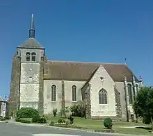
Kirche Saint-Agnan
Literatur
- Le Patrimoine des Communes du Cher. Flohic Editions, Band 2, Paris 2001, ISBN 2-84234-088-4, S. 1001–1005.
Weblinks
Commons: Jars – Sammlung von Bildern, Videos und Audiodateien
This article is issued from Wikipedia. The text is licensed under Creative Commons - Attribution - Sharealike. The authors of the article are listed here. Additional terms may apply for the media files, click on images to show image meta data.