Fontanières
Fontanières ist eine Gemeinde in Frankreich. Sie gehört zur Region Nouvelle-Aquitaine, zum Département Creuse, zum Arrondissement Aubusson und zum Kanton Évaux-les-Bains. Sie grenzt im Nordwesten an Saint-Julien-la-Genête, im Norden an Évaux-les-Bains, im Osten an Château-sur-Cher, im Südosten an Charron, im Süden an Rougnat und im Westen an Reterre.
| Fontanières | ||
|---|---|---|
.svg.png.webp)
|
| |
| Staat | Frankreich | |
| Region | Nouvelle-Aquitaine | |
| Département (Nr.) | Creuse (23) | |
| Arrondissement | Aubusson | |
| Kanton | Évaux-les-Bains | |
| Gemeindeverband | Marche et Combraille en Aquitaine | |
| Koordinaten | 46° 7′ N, 2° 30′ O | |
| Höhe | 390–575 m | |
| Fläche | 15,84 km² | |
| Einwohner | 247 (1. Januar 2019) | |
| Bevölkerungsdichte | 16 Einw./km² | |
| Postleitzahl | 23110 | |
| INSEE-Code | 23083 | |
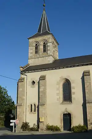 Dorfkirche Notre-Dame-de-la-Route | ||

Die vormalige Route nationale 696 führt über Fontanières.
Sehenswürdigkeiten
- Kirche Notre-Dame-de-la-Route
- galloromanischer Dorfbrunnen Saint-Blaise
Bevölkerungsentwicklung
| Jahr | 1962 | 1968 | 1975 | 1982 | 1990 | 1999 | 2008 | 2018 |
|---|---|---|---|---|---|---|---|---|
| Einwohner | 403 | 361 | 336 | 277 | 279 | 259 | 262 | 248 |
This article is issued from Wikipedia. The text is licensed under Creative Commons - Attribution - Sharealike. The authors of the article are listed here. Additional terms may apply for the media files, click on images to show image meta data.