Féniers
Féniers ist eine Gemeinde im Zentralmassiv in Frankreich. Sie gehört zur Region Nouvelle-Aquitaine, zum Département Creuse, zum Arrondissement Aubusson und zum Kanton Felletin.
| Féniers | ||
|---|---|---|
| ||
| Staat | Frankreich | |
| Region | Nouvelle-Aquitaine | |
| Département (Nr.) | Creuse (23) | |
| Arrondissement | Aubusson | |
| Kanton | Felletin | |
| Gemeindeverband | Haute-Corrèze Communauté | |
| Koordinaten | 45° 45′ N, 2° 8′ O | |
| Höhe | 772–921 m | |
| Fläche | 14,49 km² | |
| Einwohner | 94 (1. Januar 2019) | |
| Bevölkerungsdichte | 6 Einw./km² | |
| Postleitzahl | 23100 | |
| INSEE-Code | 23080 | |
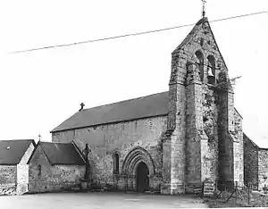
 Kirche Saint-Clair | ||
Geografie
Féniers grenzt im Norden an Gioux, im Nordosten an Clairavaux, im Südosten an Le Mas-d’Artige, im Süden an Saint-Setiers, im Südwesten an Peyrelevade und im Westen an Gentioux-Pigerolles. Der höchste Punkt in der Gemeindegemarkung ist der 921 Meter hohe Puy de Crabanat. Das Siedlungsgebiet besteht aus den Dörfern Crabanat, Le Petit Meymat, Ganneclaire, La Rebeyrolle und Le Moulin et Louvage.
Bevölkerungsentwicklung
| Jahr | 1962 | 1968 | 1975 | 1982 | 1990 | 1999 | 2008 | 2013 |
|---|---|---|---|---|---|---|---|---|
| Einwohner | 162 | 136 | 128 | 110 | 105 | 93 | 86 | 90 |
This article is issued from Wikipedia. The text is licensed under Creative Commons - Attribution - Sharealike. The authors of the article are listed here. Additional terms may apply for the media files, click on images to show image meta data.
