Flogny-la-Chapelle
| Flogny-la-Chapelle | ||
|---|---|---|
.svg.png.webp)
|
| |
| Staat | Frankreich | |
| Region | Bourgogne-Franche-Comté | |
| Département (Nr.) | Yonne (89) | |
| Arrondissement | Avallon | |
| Kanton | Tonnerrois | |
| Gemeindeverband | Le Tonnerrois en Bourgogne | |
| Koordinaten | 47° 57′ N, 3° 52′ O | |
| Höhe | 112–183 m | |
| Fläche | 23,76 km² | |
| Einwohner | 974 (1. Januar 2019) | |
| Bevölkerungsdichte | 41 Einw./km² | |
| Postleitzahl | 89360 | |
| INSEE-Code | 89169 | |
| Website | http://flogny-la-chapelle.fr/ | |

Flogny-la-Chapelle ist eine französische Gemeinde mit 974 Einwohnern (Stand: 1. Januar 2019) im Département Yonne in der Region Bourgogne-Franche-Comté. Sie gehört zum Arrondissement Avallon, zum Kanton Tonnerrois (bis 2015: Kanton Flogny-la-Chapelle) und zum Gemeindeverband Le Tonnerrois en Bourgogne. Die Bewohner nennen sich selbst Capello-Floviniens.
Geografie
Flogny-la-Chapelle liegt etwa 28 Kilometer nordöstlich von Auxerre am Armançon und am Canal de Bourgogne. Umgeben wird Flogny-la-Chapelle von den Nachbargemeinden Les Croûtes im Norden, Chessy-les-Prés im Nordosten, Marolles-sous-Lignières im Osten, Bernouil und Dyé im Süden, Carisey im Südwesten, Villiers-Vineux im Westen und Südwesten sowie Percey im Westen.
Bevölkerungsentwicklung
| Jahr | 1962 | 1968 | 1975 | 1982 | 1990 | 1999 | 2006 | 2013 |
| Einwohner | 410 | 473 | 1.137 | 1.082 | 1.070 | 1.099 | 1.010 | 1.023 |
| Quelle: Cassini und INSEE | ||||||||
Sehenswürdigkeiten
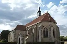
Kirche Saint-Léger
- Kirche Saint-Léger
- Kirche Saint-Hubert
- alte Käserei
This article is issued from Wikipedia. The text is licensed under Creative Commons - Attribution - Sharealike. The authors of the article are listed here. Additional terms may apply for the media files, click on images to show image meta data.