Montillot
Montillot ist eine französische Gemeinde mit 262 Einwohnern (Stand 1. Januar 2019) in der Region Bourgogne-Franche-Comté (vor 2016 Burgund) im Département Yonne. Sie ist dem Kanton Joux-la-Ville (bis 2015 Vézelay) und dem Arrondissement Avallon zugeteilt.
| Montillot | ||
|---|---|---|
| ||
| Staat | Frankreich | |
| Region | Bourgogne-Franche-Comté | |
| Département (Nr.) | Yonne (89) | |
| Arrondissement | Avallon | |
| Kanton | Joux-la-Ville | |
| Gemeindeverband | Avallon, Vézelay, Morvan | |
| Koordinaten | 47° 25′ N, 3° 49′ O | |
| Höhe | 132–319 m | |
| Fläche | 22,59 km² | |
| Einwohner | 262 (1. Januar 2019) | |
| Bevölkerungsdichte | 12 Einw./km² | |
| Postleitzahl | 89660 | |
| INSEE-Code | 89266 | |
| Website | http://www.montillot.fr/ | |
.jpg.webp) Rathaus (Mairie) von Montillot | ||

Geographie
Montillot liegt 36 Kilometer südsüdöstlich von Auxerre im Regionalen Naturpark Morvan an der Cure, die die Gemeinde im Osten begrenzt. Umgeben wird Montillot von den Nachbargemeinden Brosses im Norden und Westen, Bois-d’Arcy und Arcy-sur-Cure im Norden, Blannay im Nordosten, Givry im Osten, Asquins im Süden und Südosten, Vézelay im Süden und Südwesten sowie Asnières-sous-Bois im Südwesten.
Bevölkerungsentwicklung
| Jahr | 1936 | 1946 | 1954 | 1962 | 1968 | 1975 | 1982 | 1990 | 1999 | 2006 | 2013 |
|---|---|---|---|---|---|---|---|---|---|---|---|
| Einwohner | 336 | 330 | 329 | 326 | 310 | 269 | 250 | 261 | 278 | 280 | 279 |
| Quelle: Cassini und INSEE | |||||||||||
Sehenswürdigkeiten
- Kirche Saint-Laurent
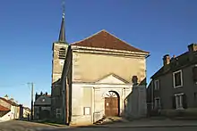
Kirche Saint-Laurent
Weblinks
Commons: Montillot – Sammlung von Bildern, Videos und Audiodateien
This article is issued from Wikipedia. The text is licensed under Creative Commons - Attribution - Sharealike. The authors of the article are listed here. Additional terms may apply for the media files, click on images to show image meta data.