Dun-le-Poëlier
Dun-le-Poëlier ist eine französische Gemeinde mit 422 Einwohnern (Stand: 1. Januar 2019) im Département Indre in der Region Centre-Val de Loire; sie gehört zum Arrondissement Issoudun und zum Kanton Valençay (bis 2015: Kanton Saint-Christophe-en-Bazelle). Die Einwohner werden Dunois genannt.
| Dun-le-Poëlier | ||
|---|---|---|
| ||
| Staat | Frankreich | |
| Region | Centre-Val de Loire | |
| Département (Nr.) | Indre (36) | |
| Arrondissement | Issoudun | |
| Kanton | Valençay | |
| Gemeindeverband | Chabris-Pays de Bazelle | |
| Koordinaten | 47° 12′ N, 1° 46′ O | |
| Höhe | 87–140 m | |
| Fläche | 22,54 km² | |
| Einwohner | 422 (1. Januar 2019) | |
| Bevölkerungsdichte | 19 Einw./km² | |
| Postleitzahl | 36210 | |
| INSEE-Code | 36068 | |
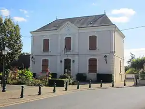 Rathaus (Mairie) von Dun-le-Poëlier | ||

Geographie
Dun-le-Poëlier liegt rund 50 Kilometer westnordwestlich von Bourges und 44 Kilometer nordnordöstlich von Châteauroux am Fouzon. Nachbargemeinden von Dun-le-Poëlier sind Chabris im Norden und Nordwesten, La Chapelle-Montmartin im Norden und Nordosten, Anjouin im Osten, Bagneux im Süden, Saint-Christophe-en-Bazelle im Südwesten sowie Sembleçay im Westen.
Geschichte
| Jahr | 1962 | 1968 | 1975 | 1982 | 1990 | 1999 | 2006 | 2013 |
| Einwohner | 676 | 593 | 576 | 523 | 496 | 457 | 484 | 459 |
| Quelle: Cassini und INSEE | ||||||||
Sehenswürdigkeiten
- Kirche Saint-Hilaire
- Priorat Saint-Vincent
- Schloss Fins, Domäne aus dem 17./18. Jahrhundert
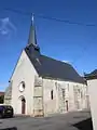 Kirche Saint-Hilaire
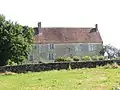 Priorat
Weblinks
Commons: Dun-le-Poëlier – Sammlung von Bildern, Videos und Audiodateien
This article is issued from Wikipedia. The text is licensed under Creative Commons - Attribution - Sharealike. The authors of the article are listed here. Additional terms may apply for the media files, click on images to show image meta data.