Fontenay (Indre)
Fontenay ist eine Gemeinde mit 89 Einwohnern (Stand: 1. Januar 2019) im französischen Département Indre in der Region Centre-Val de Loire. Sie gehört zum Kanton Levroux (bis 2015: Kanton Vatan) im Arrondissement Issoudun. Die Einwohner werden Fontenois genannt.
| Fontenay | ||
|---|---|---|
| ||
| Staat | Frankreich | |
| Region | Centre-Val de Loire | |
| Département (Nr.) | Indre (36) | |
| Arrondissement | Issoudun | |
| Kanton | Levroux | |
| Gemeindeverband | Champagne Boischauts | |
| Koordinaten | 47° 4′ N, 1° 45′ O | |
| Höhe | 118–171 m | |
| Fläche | 12,46 km² | |
| Einwohner | 89 (1. Januar 2019) | |
| Bevölkerungsdichte | 7 Einw./km² | |
| Postleitzahl | 36150 | |
| INSEE-Code | 36075 | |
| Website | http://www.fontenay-en-indre.com/ | |
Geografie
Zu Fontenay gehören neben der Hauptsiedlung auch die Weiler Lussault, Les Deserts und Les Planches. Angrenzende Gemeinden sind Guilly im Norden, La Chapelle-Saint-Laurian im Osten, Liniez im Süden, Bouges-le-Château im Westen sowie Rouvres-les-Bois im Westen und Nordwesten.
Bevölkerungsentwicklung
| Jahr | 1962 | 1968 | 1975 | 1982 | 1990 | 1999 | 2006 | 2013 |
|---|---|---|---|---|---|---|---|---|
| Einwohner | 200 | 175 | 133 | 111 | 92 | 86 | 81 | 93 |
| Quelle: Cassini und INSEE | ||||||||
Sehenswürdigkeiten
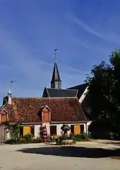
- Kirche Saint-Étienne aus dem 16. Jahrhundert, Monument historique seit 2005
- Kapelle aus dem 16. Jahrhundert
- Schlösser von La Dixme

Ortszentrum mit Kirche Saint-Étienne
Weblinks
Commons: Fontenay – Sammlung von Bildern, Videos und Audiodateien
This article is issued from Wikipedia. The text is licensed under Creative Commons - Attribution - Sharealike. The authors of the article are listed here. Additional terms may apply for the media files, click on images to show image meta data.
