Saint-Aubin (Indre)
Saint-Aubin ist eine französische Gemeinde mit 167 Einwohnern (Stand: 1. Januar 2019) im Département Indre in der Region Centre-Val de Loire; sie gehört zum Arrondissement Issoudun und zum Kanton La Châtre (bis 2015: Kanton Issoudun-Sud). Die Einwohner werden Saint-Aubinois genannt.
| Saint-Aubin | ||
|---|---|---|
| ||
| Staat | Frankreich | |
| Region | Centre-Val de Loire | |
| Département (Nr.) | Indre (36) | |
| Arrondissement | Issoudun | |
| Kanton | La Châtre | |
| Gemeindeverband | Champagne Boischauts | |
| Koordinaten | 46° 51′ N, 2° 2′ O | |
| Höhe | 142–181 m | |
| Fläche | 28,63 km² | |
| Einwohner | 167 (1. Januar 2019) | |
| Bevölkerungsdichte | 6 Einw./km² | |
| Postleitzahl | 36100 | |
| INSEE-Code | 36181 | |

Geographie
Saint-Aubin liegt etwa 25 Kilometer ostnordöstlich von Châteauroux. Umgeben wird Saint-Aubin von den Nachbargemeinden Issoudun im Norden und Nordwesten, Chouday im Nordosten, Ségry im Osten, Chezal-Benoît im Südosten, Pruniers im Süden, Meunet-Planches im Westen und Südwesten sowie Condé im Westen und Nordwesten.
Im Gemeindegebiet liegt der Flugplatz Issoudun-Le Fay.
Bevölkerungsentwicklung
| Jahr | 1962 | 1968 | 1975 | 1982 | 1990 | 1999 | 2006 | 2013 |
| Einwohner | 217 | 183 | 142 | 126 | 155 | 169 | 162 | 198 |
| Quelle: Cassini und INSEE | ||||||||
Sehenswürdigkeiten
- Kirche Saint-Aubin
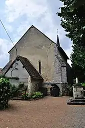
Kirche Saint-Aubin
Weblinks
Commons: Saint-Aubin – Sammlung von Bildern, Videos und Audiodateien
This article is issued from Wikipedia. The text is licensed under Creative Commons - Attribution - Sharealike. The authors of the article are listed here. Additional terms may apply for the media files, click on images to show image meta data.